The park IS open, sort of. If you'd like to walk (or bike) a few extra miles (6-17 to be exact), you too can attempt the summit this winter. The obvious benefit to this twisted scenario is that you'll have almost no competition for high camp permits! The downside is that you'll have to carry a few extra things (food, fuel, other supplies) to make your (longer) trip possible.
If you're climbing on the south and west side of the mountain (via Paradise and/or the Westside Road), get your permit during business hours from the rangers at the Nisqually Entrance. If you'd like route, permit and parking information, please drop me a note. If you're headed up the Carbon or White River drainages, you can still self register.
More soon about how to volunteer or donate to Mount Rainier's flood recovery efforts.
Happy Holidays
I hear that visitors with reservations to the National Park Inn (in Longmire) will be granted access to Longmire over the holidays. The inn will be responsible for shuttling them into and out of the park. I don't think this shuttle system will be available to general park visitors however... In the meantime, the NPS is working on a plan to allow public access to the mountain via the Westside Road. More on that when the details are ironed out.
If you're interested in climbing routes on the westside, like Tahoma Glacier, you may have a reasonable shot at that summit this winter! This access, btw, may be the shortest distance to the mountain when compared to HWY 410 and Carbon River Road.
My updates have been limited, b/c I've had little access to the internet. More when I return to the Pac NW!
Happy Holidays everyone.
Access is difficult
I reported that Paradise would open late this winter and that prediction is spreading. The News Tribune now says March... They also increased the estimated cost to date: $791 K. As noted earlier, the repairs at mileposts 5 and 9 will each take a minimum of 1-2 months The question is, can those repairs take place concurrently? I also wonder about the difficulty of doing such work in the middle of Mt Rainier's winter. Dare we say...???
Over the next few months, there will be a number of events around the Puget Sound (and maybe beyond) to raise awareness to Mt. Rainier's flood and recovery work. They are a great opportunity to reconnect with the park and discuss what's happening on the mountain. My first scheduled talk/show is on Jan. 19th at the Mountaineers Clubhouse in Tacoma. I'll put more information up about the program when the details settle.
The suggestion to access the mountain from Highway 410 was well intended, but we've since learned that the state doesn't allow any parking along HWY 410 near the park boundary. You either have to have someone drop you off, or [READER CONTRIBUTED UPDATE] park in the small pullout on the right, which isn't always plowed, as you turn onto Crystal Mountain Blvd.
Speaking of intrepid climbers, a few showed up at Nisqually Entrance wanting to hike the Nisqually Road to Paradise. The road corridor, however, remains closed. There is some talk of allowing access to the westside road or Longmire, but those issues are still up in the air and largely depend upon the repairs at Sunshine Point and Kautz Creek. Stay tuned.
Pristine, Pink, Breathless
 That's what it was like on the mountain this weekend. I made it to Camp Muir Saturday, my first opportunity in over two months. Finally, time to survey the camp and search for possible storm damage (and test the snow conditions on the Muir Snowfield).
 Things looked normal for early December. There was access to the public shelter, but the toilets were drifted in with deep snow. As for obvious signs of rain and wind damage, it seems that only the NPS suffered. We lost two storage boxes. The weather telemetry equipment for the NWAC appears to be working. It's my hope that once the power resumes at Paradise, the weather data will come back up online.
 I was a bit surprised that there wasn't more snow cover between 7-11k. Everything looked wind scoured, i.e, lots of exposed rocks along the eastern edge of the Muir Snowfield, Cowlitz Cleaver, Muir Rock, etc. As for the upper mountain, the Nisqually Glacier looked very, very good. And while we're talking, so did the Nisqually Cleaver and Gib Ledges. Plenty of snow and ice in those rocky steep sections
 After surveying the camp, it was time to confirm the conditions on the Muir Snowfield. And it was just as I thought it would be: 4,500 feet of untracked packed powder, with a few rocky areas around McClure. As you can see, the mountain turned pink for our descent. Top photo by Ethan McKinley
JUST IN: The Camp Muir and Paradise weather telemetry data are back up. I hope they last! I know that they ran the generator at Paradise today.
691K
When I said it was going to be tough to climb Mt. Rainier again in 2006, it wasn't meant to deter any ambitious climbers. In fact, for those motivated enough, the summit is still available. It's just that you're going to have to start at a lower elevation and hike a lot further. The best access is probably at the Highway 410 closure near the Crystal Mountain turnoff. But if you were REALLY determined and wanted to say, climb Liberty Ridge, you could start at the Carbon River entrance. Either way, please make sure that you self register when you go. And if you'd like, write me for the latest gossip on road access.
As for public access to Paradise, it's still going to take a while based on the conservative estimates prepared by the federal highway engineers. The main obstacles are at mile makers 5.2 and 9.1. In both areas, the road is compromised by landslides, that will take two months (minimum) to stabilize and/or reroute around.
And the infamous Kautz Creek stream jump??? (Remember, the creek flows over the road) Superintendent Dave Uberuaga elected to have NPS crews raise the road bed and install more culverts. The other option kicked around involved a large bulldozer and over 1 mile of chainsaw work and cat tracks into the wilderness. That plan called for diverting the stream back into its original channel. A bulldozer partially explored this option early on, but a number of wilderness advocates expressed concern over the invasive procedure and it was put to rest. Regardless, the Kautz Creek recovery is closer to completion than the other repairs listed above.
And while we're discussing repairs, I was informed today that the park has spent over $691,000 on flood response and recovery, and the job is far from done! In Longmire, we're relying on generator power which means that our sewer system is still down... Though decisions and progress are being made, the road to full recovery is a ways off. I did hear one really reassuring comment from the Deputy Superintendent Randy King. He said "we intend to repair all the roads, all of the facilities, all of the trails damaged by this storm." In essence, the park is doing all that it can to be fully functional for next spring and summer.
Climate, Politics, Climbing on Mt Rainier in 2006
You better make the most of this cold snap and powdery snow if you're listening to the WA State Climatologists. They believe that the current trend of sub-freezing temperatures and record-setting precipitation doesn't mean much when discussing the long term forecast. They are still calling for a warmer, drier winter.
On to politics... Sixth District U.S. Congressman Norm Dicks discussed his view of global warming and Mt. Rainier in The Olympian. More importantly, he seems to have ponied up the $30 million dollars needed for estimated flood repairs:
On to politics... Sixth District U.S. Congressman Norm Dicks discussed his view of global warming and Mt. Rainier in The Olympian. More importantly, he seems to have ponied up the $30 million dollars needed for estimated flood repairs:
"But everyone knows that the long laundry list of repairs,which the park estimates could run up to $30 million, will happen. 'We'll get the money in a supplement bill or in the 2007 budget,' said Rep. Dicks"And a little climbing info... It's going to be really tough for anyone to ascend Mt. Rainier again in 2006, unless something miraculous happens fast. But speaking of money (30 dollars, not 30 million) one climber inquired about a 2006 climbing pass refund... We had to say sorry, there are no refunds, especially for this natural disaster.
Heavy Snowfall
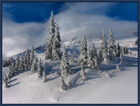 Sub-freezing temperatures and heavy snowfall dominate the mountain and complicate the flood recovery. Since Tuesday the 21st, over 77" of new snow has fallen at Paradise; as of Sunday the 26th, there was 71" on the ground (note the compaction). In Longmire, we measured 7" of new today for a total of 26" on the ground and it's still November! Winter has arrived, in full force.
 I added a new blog, Flood Photos and More, to address the importance of the event and recovery. At this stage, I haven't been able to organize it, but in the next few days there will be more images and narratives. Stay tuned...
In the meantime, I appreciate your emails and thoughts. Sally Johnson sent this photo (taken last Fall) to say that she misses Paradise, especially during the first few snowstorms that blanket the meadows and trees. But Sally is not the only one lamenting the lack of access. A few of you have even posed some interesting questions in hopes (I think) of getting back on the mountain. So to be clear, we don't need backcountry skiers to test the snow stability near Paradise. Yes, I understand that ski-compacting fresh powder might reduce the avalanche hazard.
Turducken
It was 28 degrees at Paradise yesterday (Wed) with 14 inches of powdery new snow. And after today's deluge and temperature drop, we can safely assume that AT LEAST another foot fell. With such snowfall, I'd normally be optimistic about our winter snowpack and climbing conditions. But for the next month (and it sounds like more) we'll probably have to get our climbing, skiing, and other winter thrills elsewhere. An article in the Seattle Times says that "In a "best scenario," the gate to Longmire will open by Christmas." Notably, there were no predictions about the road to Paradise being restored. Hummm...
So it's Thanksgiving... and I am quite thankful that the Nisqually River didn't wash my home away this year. I am also thankful for the turducken I ate. You know, a chicken stuffed inside a duck stuffed inside a turkey. It's de-boned and filled with all sorts of Cajun goodness and it tastes absolutely delicious! So why do I share this culinary tidbit? Because a turducken is something you can obtain right now. But if you wanted that powdery snow at Paradise, the snowpack reports might be torturous given the current access.
Happy Thanksgiving!
Political attention & during/after Mt Rainier's flood photos
Mt. Rainier is getting a lot of attention these days. On the political side of things, the new Director of the National Park Service, Mary Bomar, visited last week. She toured flood damaged areas firsthand and spoke with NPS personnel about the event, the progress and the longterm difficulties. And today, U.S. Representative Norm Dicks followed suit. The Congressman also visited many of the damaged areas, and like Mary, wanted to get a better sense of what it was going to take to get Mt Rainier National Park reopened.
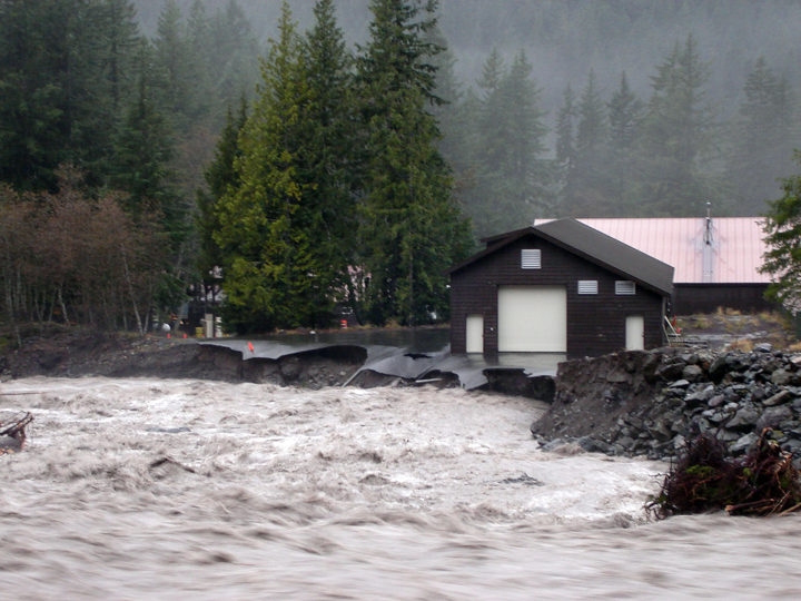
 This flood/rain/storm event has made evident the challenges of managing facilities and roads in the shadow of a major glaciated peak that is slowly loosing its glaciers. Kautz Creek is quickly becoming the poster child of how Mt. Rainier National Park will manage this complex situation. As it stands now, Kautz Creek continues to flow over the Nisqually to Longmire road because it jumped its main channel upstream in an area that is legally designated "wilderness." The hard question is, how do you provide safe, reliable, and financially feasible road access through a threatened drainage that is known for glacial outbursts and episodic floods? The photo above displays the culprit, Kautz Creek, shortly before it enters unchartered forest as it forms a new channel. This picture was taken roughly one mile upstream from where the creek now intersects the main road.
 And speaking of photos... Here is another set of "during and after" pictures of Mt. Rainier's flooding. This set focuses on the Nisqually River bridge near Longmire, seen here on Nov. 6th.
 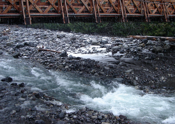 Compare this to roughly the same image today, an obvious contrast to the muddy storm flow above.
Heavy equipment and during/after photos
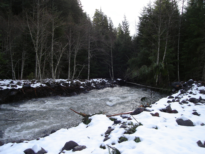
 The road to Mt Rainier National Park's recovery is passing through some interesting terrain. Today, I saw a large bulldozer working in the Nisqually River. One of the vexing problems for the NPS is that rivers and streams have jumped their main channels. During a storm, riverbeds can become filled with debris, which in turn causes the river's flow to change its course. To some extent, that is why the Emergency Operations Center was threatened, and why the stream jump at Kautz Creek is causing such a repair headache. So to protect the facilities in Longmire, heavy equipment is now being used to clear the build up of rock, logs and other debris from the last rainstorm and flood.
 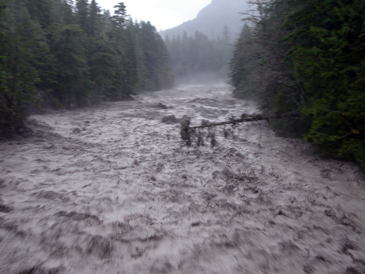 The historian in me wanted to capture a during and after view of the Nisqually River. Here is the "during" image from Monday afternoon, Nov. 6th when things really started to roll. This picture is taken from the Longmire bridge looking upstream.
 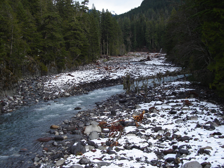 And here is the "after" view, taken today Nov 17th. Note the tree that hangs over the Nisqually River in both photos, and also the color of the river.
Mt Rainier Storm & Flood Damage Photos - Carbon/Ipsut
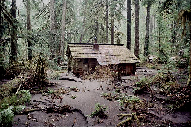 The NW corner of the park usually has its own share of flood related damage each year. And though it's not unusual for there to be Carbon River inspired washouts, this rainstorm brought substantially more destruction to the area. For example, here is the idyllic Ipsut Creek Cabin. It suffered heavily during the flood. Is it me, or does this place remind you of Yoda's house on Dagoba?
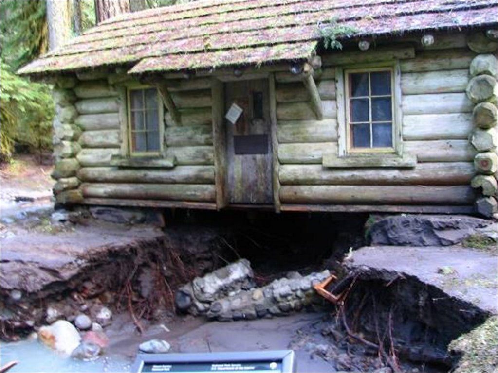 This creek diversion gives literal meaning to the name, Ipsut Creek Cabin. If Yoda did live here, he'd have to use quite a bit of "the force" to fix things.
 As for the Carbon River Road, more than two miles of it washed away in at least four separate spots. In some places, the river flowed down the middle of the road (like here). For climbers, this could spell delay in early season attempts of Liberty Ridge.

AND another washout closer to Ipsut Creek Campground.
As for the Wonderland and other park trails, here's a brief run down on the storm damage. Keep in mind, the full extent may not be known till next spring, as these assessments were made from the air. For now, backpackers should probably expect things (bridges) to open up later than normal next summer. There are at least 10 bridges out around the Wonderland Trail. New trail needs to constructed in four other places. That includes a half mile reroute between Lake James and Cataract Creek and another 750 foot section in Stevens Canyon. NPS Photos
Mt Rainier storm & flood damage photos - Ohanapecosh
 Snow is accumulating at Paradise. I measured 46" total, with 15" of fresh snow this morning. It looks and feels like winter and if the park were open, skiers, boarders and snowshoers would be enjoying the early snowfall. But the floods really did a number on the roads and as the days pass, it becomes more clear how complicated the damage is, especially with the prompt arrival of winter.
Since it's going to be difficult to write about the climbing routes and upper mountain while the park is closed, I will devote more energy to the events surrounding the park being reopened. There will be updates, damage assessments, projected repairs and ongoing weather observations. I'll also pull together photos, when possible, like these NPS pictures of the Ohanapecosh area.

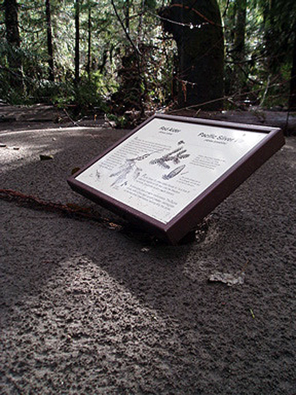
Above left is an interpretive sign in the Grove of the Patriarchs that has been flooded with mud and silt. Normally, this type of sign rests about 3 and 1/2 feet above ground.
The heavy rain also lead to a number of landslides, like this large one near Ohanapecosh Campground. The slide started on the road above (out of image) and swept everything in its path down to the Ohanapecosh River and Campground.
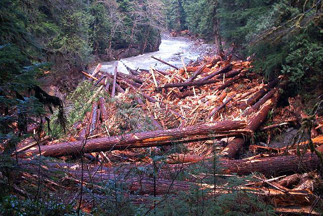 Here is the primary deposition zone for all of the timber that was unearthed in the same landslide.
  The river also moved and in doing so, took a couple of the campsites with it. Here is the new loop C of Ohana.
SNOW... and more flood damage photos
 In the newspapers, NPS officials predict road openings as late as Christmas, but cautiously hope it will happen sooner. At this time, it's difficult to tell just how long it will take to get things ready. Another complication is the ongoing Paradise construction project. The contractors had planned to work continuously this Fall and this isn't helping. In the meantime, I'm cheering for the road, electric and water treatment crews who are hustling to get things reopened.
It snowed in Longmire Friday night. It was only a few inches, but enough to ignite those enthusiastic dreams of pristine mountaineering and great backcountry runs. Paradise measured 18 inches of new snow Saturday and 21 more today, Sunday! The National Weather Service is calling for another storm, which has already started off colder.
 Here are a few extra images that I didn't weave into the blog earlier. To the left is the only road into the Kautz Helibase. This one may not be so easy to repair, because some of the creeks have changed their course and now flow down road corridors.
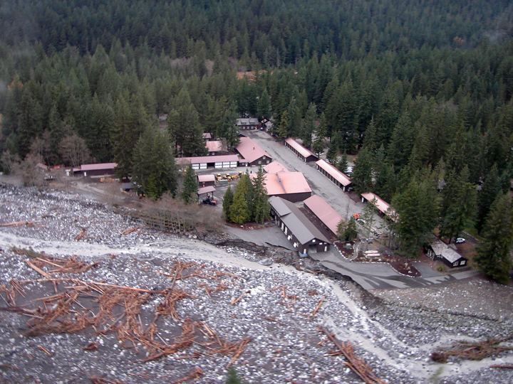
The main image above is of Longmire from the air. You can note that the river's flow has decreased, that there are a number of recently uprooted large trees and new log jams, and that the river came very close to taking out the Emergency Operations Center.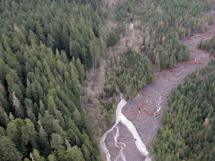 As for creeks that change their courses, the main one of concern so far is Kautz Creek. It jumped its main channel about a mile above the road, and now runs through the forest as seen in this aerial photo. Note the dry creek bed where it once flowed. You can also see the younger forest as compared to the older growth.
A mountain of maintenance
I've been wondering about the upper mountain. It must be snowing up there today, because the temperatures are much cooler here in Longmire. The Camp Muir and Paradise weather stations are both offline... Perhaps they are casualties of the intermittent disruption of power, phone and internet. I do know this: there was 7 inches of snow on the ground at Paradise yesterday, and I can see a snowline at 3,500 feet today.
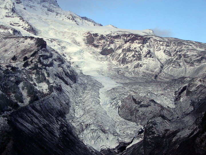
 I am also wondering about all that rain on the glacier. I have a feeling that at some elevations, the rain turned the glacier into hard/bulletproof ice when the temperature dropped. Here is the Nisqually Glacier from the air, taken on Wednesday.
It has been raining steadily today, but the river flow and currents have remained normal. Access to the backcountry and mountain is dependent upon repairing the park's infrastructure. A lot of cranes, dozers, and dump trucks will be needed to re-sculpt the land for roads and sewer systems. Like today, I saw a large crane moving rock in the Nisqually River in order to help protect a historic cabin, road and treatment plant. But it's not everyday you see this sort of thing in a national park.
There was another spate of articles online at MSNBC and in the local papers about the park closure and flood damage. The big pieces were in the News Tribune, Seattle Times and the Yakima Herald. In the meantime, let there be colder temps and stable weather.
Regaining ground in the park, the NPS makes its move
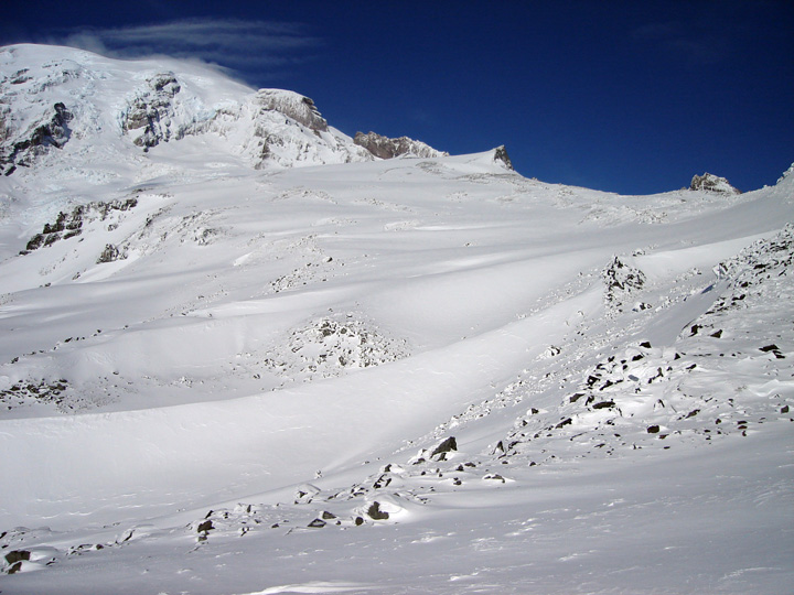
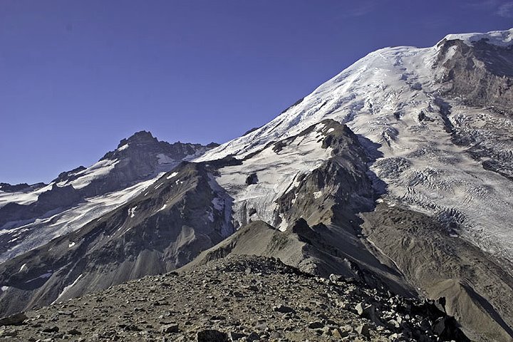
 The skies parted for a while today and the mountain finally revealed itself. Plastered ice and snow coated the upper 3-4,000 feet, seen here from a recently improved view point near Kautz Creek. Everything below 9-10,000 feet appeared thin and icy, i.e. very little winter snowpack, see below. Rumor has it, another storm is on the way. I hope it brings colder temps.
 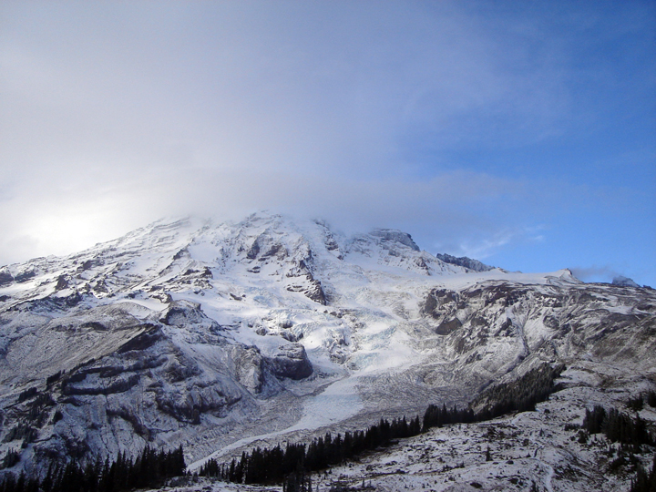 I snapped this image late today before the clouds returned. That is the Nisqually Glacier on Mt Rainier, the trails of the Paradise area in the foreground. The glacier ice looked really blue after the intense rain, and the mountain looked awesome.
For 24 hours, this was a place that people simply left. Today, the NPS resummed its plan to restore facilities and order to the park after 18 inches of rain fell at Paradise in 36 hours. The level of the primary rivers and tributaries remains high and it's very easy to note the newly scoured banks and freshly deposited log jams along the river corridors.
 There was a noticeable change to the silence as the restoration effort moved forward. Electricians, water treatment specialists, and heavy equipment operators returned to Longmire and other parts of the park to assess the damage and begin the repairs. Highway 410 will open soon (probably Thursday) but the Carbon River road, Highway 123 and the Nisqually to Paradise road will remain closed (probably for a few weeks).
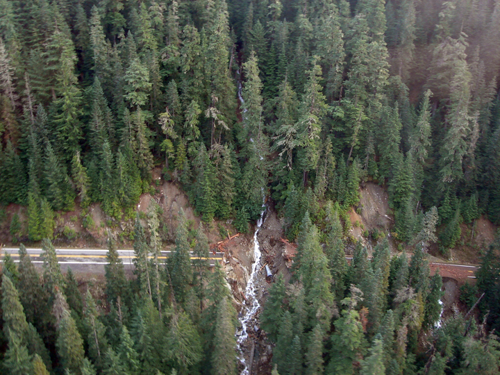 We surveyed the storm damage from the air this afternoon. The main hits were taken at Sunshine Point, Stevens Canyon (in somewhat predictable locations, see photo above-left) and on Highway 123 (left) where the road washed out entirely. The damage to Highway 123 looked severe given the time of year; I wonder if it won't be fully sorted out until 2007. At the Sunshine Point washout, I saw earth movers in the remains of the campground (now river bed). They were trying to make things happen for the road to Longmire, but the job seemed large because the road was entirely gone.
The sound of silence approaches, as soon the generators will be turned off for the evening.
Power: Nature turned Generator
 The rain seems to have stopped and now you can hear the Longmire generators (6-10 am and 4-8 pm that is). It's going to take some time to put things back in order, but it seems as though the main brunt of the storm and its damage have subsided.
 Sunshine Point Campground near the Nisqually Entrance was disappointed with the weather trend and left Mt. Rainier National Park for sunnier locations. The problem is that it took the main road with it. I couldn't get a visual though because the road near Kautz Creek was under 3 feet of silty debris and water. The creek must have diverted upstream and chosen a new channel. See photo above.
 If you're familiar with the park, you'll notice a number of "new viewing areas" along the Nisqually to Paradise corridor next time you visit. The Nisqually River ran bank to bank and in doing so, took a massive amount of debris with it. Large trees fell, as new embankments were chiseled.
 Here is another image of the westside road. See it? Neither do I. Well, 8 pm is approaching...
Evacuation and Damage
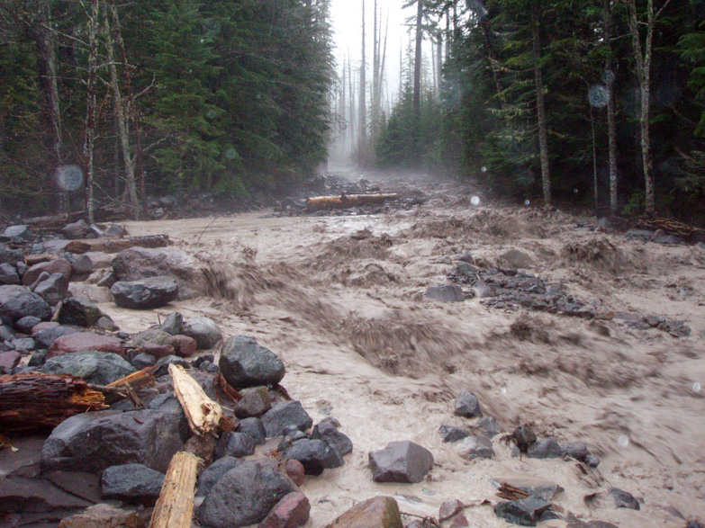
 The Park remains closed until further notice. For updated information, call 360 569 2211 ext 9.
 The onslaught of rain continued throughout the night. The Paradise telemetry recorded another 7 inches, bringing the total to 18 inches of precip over the course of the storm... and it's still raining!
 Aside from the rage of the Nisqually River, Longmire is a relatively quiet place. The NPS has closed its offices, and only essential personnel are allowed in through a backroad (which is largely washed out and requires shuttles). See image above, taken near the Eagle Peak Trailhead...
The flooding has seriously damaged or threatened many of the roads (and even a few of the facilities) in the park. This image was also taken from the Longmire backroad below the Community Building. You can see where the road once existed.
 Longmire is isolated by washouts and mudflows, so it feels like a safe little island. Well, "safe" unless you're in the Emergency Operations Center (pictured left) which is being undermined by the Nisqually River... Oh, and some of the electrical and water systems are also damaged, but most of the facilities will probably survive the storm.
 I'll provide updates when possible. If you plan on visiting this side of the park anytime soon, consider that it's going to take a few days to repair the main road between the Nisqually Entrance and Longmire. I hear that it's completely washed out near Sunshine Point Campground. And speaking of that campground, it's GONE.
No, it's REALLY raining up here
The southside of the park is closed; the rain has started to wash out or significantly threaten a number of roads and access points. For updated information about weather and access, call 360 569 2211 and press ext 9.
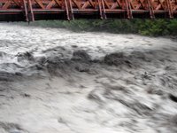
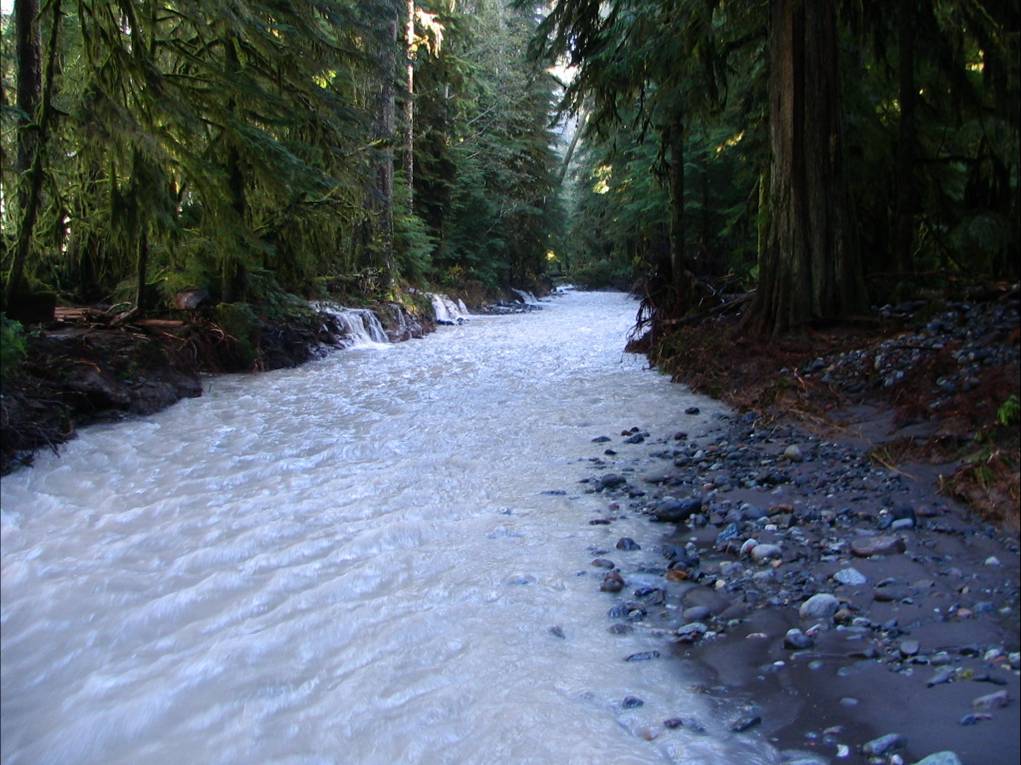
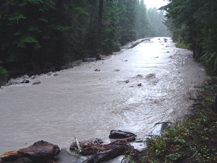
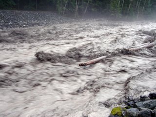 Updates: the weather observations for Paradise measured 11.3 inches in the past 24 hours! At Camp Muir, the temps hovered in the mid 30's (probably rain) but it was the wind speed that remained impressive. Gusts of 121 MPH were recorded and the average wind speed for one hour in midday was 101!! The Nisqually River (pictured right) is nothing short of a boiling chocolately torrent, as is every other creek and stream around here. The river sounds like a freight train and the ground trembles as large boulders and old-growth trees jostle into the flow. The air even smells of glacial mud, cedar and pine.
As it stands now, the NPS is evacuating any non-essential personnel from the park before the roads completely wash out. The Carbon River road is also closed, as is the rest of the park.
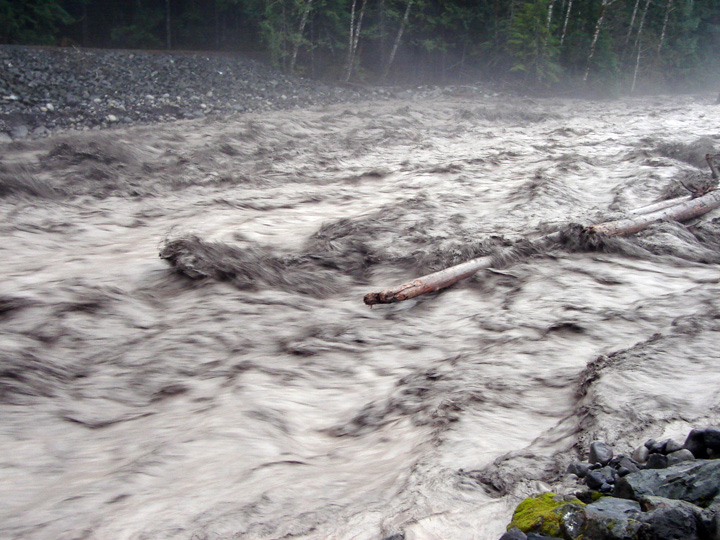 Updates: the weather observations for Paradise measured 11.3 inches in the past 24 hours! At Camp Muir, the temps hovered in the mid 30's (probably rain) but it was the wind speed that remained impressive. Gusts of 121 MPH were recorded and the average wind speed for one hour in midday was 101!! The Nisqually River (pictured right) is nothing short of a boiling chocolately torrent, as is every other creek and stream around here. The river sounds like a freight train and the ground trembles as large boulders and old-growth trees jostle into the flow. The air even smells of glacial mud, cedar and pine.
 As it stands now, the NPS is evacuating any non-essential personnel from the park before the roads completely wash out. The Carbon River road is also closed, as is the rest of the park.
Hard Rain
It rained 7 inches in the past 19 hours at Paradise. We are hoping for snow, but the possibility seems remote. The Camp Muir telemetry says that it's been above 32 F since mid day Sunday. Interestingly, there was no wind measured while below 32 F, however once the temp stabilized above 34 F, the anemometer proudly reported gusts up to 118 MPH!! Zero-118 in one hour... maybe the equipment froze? Regardless, Camp Muir is probably a miserable place to be right now.
More soon...
More soon...
The snow is flying
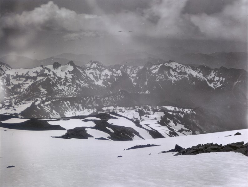 The temperatures plummeted today, and along came precipitation in the form of quite a bit of snow! Camp Muir saw a 29 degree drop in the temperature during the night. Paradise didn't drop that far, but there is some fresh stuff on the ground as the temp hovers near 31... which should help w/ that Muir Snowfield dilemma. A reader contributed this July 29 image taken in 1896! Check out the amount of snow.
It seems that the Camp Muir telemetry has been spotty. It's up and running now, but is occasionally down. I've been told they're going to fix the problem.
Found
Sarah Heitman, a 21 year-old student attending UPS in Tacoma, was found safely today by ground and aviation teams after two days of searching. Sarah failed to return from a planned 4 day backpack trip around the Northern Loop trail; she departed from Ipsut Creek Campground last Saturday and was scheduled to return on Tuesday. By Wednesday night, her friends at UPS became concerned and notified campus security who then called the park service.
Numerous SAR (Search and Rescue) resources from around the state took part in the response: Tacoma, Seattle, and Olympic mountain rescue units, as well as the WA State Department of Emergency Management, German shepherd search dogs, King County Guardian Helicopter, and Olympic and North Cascade National Park personnel. I know I speak for Sarah's family, as well as for myself, in expressing thanks to everyone for their efforts in successfully completing this mission!
Numerous SAR (Search and Rescue) resources from around the state took part in the response: Tacoma, Seattle, and Olympic mountain rescue units, as well as the WA State Department of Emergency Management, German shepherd search dogs, King County Guardian Helicopter, and Olympic and North Cascade National Park personnel. I know I speak for Sarah's family, as well as for myself, in expressing thanks to everyone for their efforts in successfully completing this mission!
Change of plans
Unfortunately for me, the stars realigned today and I had to cancel my trip to good ol' Louisiana. More on those circumstances later. There is one small upside: I'll be in the park over the weekend and may have a chance to get some aerial shots of the mountain. If so, I'll post them.
The News Tribune covered our successful summer of no rescues. They also took some time to discuss the new guiding operations.
As for climbing, the weather looks good for the weekend, but that wasn't the case this week. It seemingly rained almost every day, and there wasn't much snow to show for it (as it stayed quite warm). Camp Muir reached a high of 40 degrees Thursday! If you're on the mountain, watch for hard ice, as it seems to appear after those warm rain storms.
Rain/Snow
Yup, the rain/snow is here for the season (though the weekend does look nice.) There was some fresh snow on the Muir Snowfield earlier this week, but the freezing level jumped back up to over 10,000' today, so the wintery white goodness is probably suffering under the burden of the Pineapple Express (note: temps at Muir reached 37 degrees).
As an observation, climbing visitation has dropped quite a bit over the past few weeks. I wish that I had more to share about things on Rainier. Work, however, has detailed me to Olympic National Park because of a tragic employee accident. Therefore, my ability to be on the mountain has been nil.
And with that said, I'll be visiting New Orleans next week... With a nickname like "Gator," you have to visit the relatives on occasion. Since Hurricane Katrina, I've been MIA, so it's time to reconnect w/ my bayou blood. BTW, a number of folks say I look (and sometimes act) like James Carville... Is that true?
As always, if you've any (and I mean ANY) field reports, please send them along, as they are greatly appreciated. I hope the fall is treating you all well.
Earth Shaking News...
The much anticipated news about the guiding contracts is gaining traction in the local press. The News Tribune and the Seattle P-I both did stories (the Seattle Times ran an AP piece). In addition, the PI discussed some other interesting facts about the 2006 climbing season (which technically ends on Dec 31st)... Those being that the success rate is up and that there were no cries for rescue on the upper mountain. I jokingly wondered if the blog could share in some of the credit?! :)
Oh, and for some real earth shaking news, Mt Rainier had a small quake a few days ago.
Oh, and for some real earth shaking news, Mt Rainier had a small quake a few days ago.
Mount Rainier Guiding Concessions
Here is some worthy Mount Rainier climbing news... Today, the NPS released the names of the companies that successfully competed for the future guiding contracts on the mountain. You may recall, the NPS went through an extensive commercial services planning (CSP) process over the past 4 years. The finalized plan, published in the spring of 2005, called for three guide service concessions to operate on Mount Rainier (as opposed to one, RMI). The CSP set a number of parameters for the next 10 years, including commercial use levels and commercial free zones, yet it also opened up the possibility for varied forms of guiding and training to occur. Many felt the plan was a historic step forward for the NPS, resource protection and for the mountaineering industry.
SOOO, who recieved the contract awards???... Rainier Mountaineering Inc., International Mountain Guides, and Alpine Ascents International. We'll provide the official press release later, but the word is out and we thought you should know.
SOOO, who recieved the contract awards???... Rainier Mountaineering Inc., International Mountain Guides, and Alpine Ascents International. We'll provide the official press release later, but the word is out and we thought you should know.
Fall - Rock-tober
There isn't a whole lot to say about specific climbing conditions on Mt Rainier these days. It's mid fall, it's beautiful, it's quiet. For climbers, the issue revolves around dry glaciers and lots of exposed bare rock (volcanic rock that is). A few of the steeper routes (Mowich/Ptarmigan) may come back into shape, but those are a gamble. Most of the fresh snow is now 4 months past and the new stuff doesn't seem to really accumulate till November (sometimes later).
All that said, if you'd like the mountain mostly to yourself, some of the finest days to climb are happening right now. That's because the weather has been quite good overall (it's predicted to remain so for another week) and the DC remains climable.
The reponses to the Muir Snowfield question are stilll coming in. As of yet, no one has desented from the general observation: the snow and ice on the Muir Snowfield seem to be visibly shrinking! To those who wrote, thank you. To those who didn't... :)
Muir Snowfield and the Disappointment Cleaver Route
 Check out this 2x6 style of crevasse crossing. The image was snapped over the weekend (thankfully the board didn't)... The lumber has since been pulled, so now climbers must find another way around the crevasse. Here's more on the DC...
I received a few comments about the ice mass on the Muir Snowfield. Avid Rainier skier Ron Jarvis had this to say,
"When I started playing on Rainier in 1991 there were no dismounts required while skiing from Muir to Pebble in late summer/fall and as I recall that seemed to be the case right up until the last 2 or 3 years (dementia notwithstanding :-) ).
I would also add that similar conditions (volume/snow-ice depth) also seem to be the case on the contiguous neighbor to the east, the Paradise Glacier."
The Muir Snowfield
Camp Muir was quiet this weekend, but a few teams made the summit via the Disappointment Cleaver. We'll post our report soon. In the meantime, I've updated the conditions on the Muir Snowfield.
And about that Muir Snowfield... I had a good conversation with a senior RMI guide about the level of the snowpack on the snowfield. We both felt that there was a noticeable drop in how it measured against the rocks. That is, the surface of the snow seems to have lowered, thus exposing more bare ground. It appears to my untrained scientific eyes that the ice mass underneath is melting and diminishing, leaving less ice-volume throughout the snowfield. The surface appearance seems normal for this time of year with ice, some fresh snow, and a few crevasses, but the overall snow level seems to have decreased. In essence, we noticed more exposed mounds of sand, pumice and volcanic rock. I'd be curious to hear if anyone who hikes the snowfield a lot is left with a similar impression.
And about that Muir Snowfield... I had a good conversation with a senior RMI guide about the level of the snowpack on the snowfield. We both felt that there was a noticeable drop in how it measured against the rocks. That is, the surface of the snow seems to have lowered, thus exposing more bare ground. It appears to my untrained scientific eyes that the ice mass underneath is melting and diminishing, leaving less ice-volume throughout the snowfield. The surface appearance seems normal for this time of year with ice, some fresh snow, and a few crevasses, but the overall snow level seems to have decreased. In essence, we noticed more exposed mounds of sand, pumice and volcanic rock. I'd be curious to hear if anyone who hikes the snowfield a lot is left with a similar impression.
Stellar weather and long term forecasts
 I found this long term forecast from the Climate Impacts Group. They've done a little weather projecting into the fall and winter (and even the spring). Here is an excerpt,
The seasonal outlooks through spring 2007 suggest... a continuation of warmer than average conditions throughout the region for the coming fall, winter, and spring seasons... pointing toward[s] a weak-to-moderate intensity El Niño event for the next few seasons... suggest[ing]... an anomalously dry fall and winter for much of the region.Of course there were some serious disclaimers, but if you follow this prediction, the forecast doesn't look so hot for skiers.
In the meantime, it's warm and dry on the mountain. Camp Muir enjoyed a balmy low of 49 last night! It's at 59 degrees as of 9 AM.
Image by Rob Veal
Vacation...
If you haven't noticed, there have been few updates over the past 2 weeks... my apologies. This is largely due to the fact that I took a much needed climbing vacation. But I'm back, and with such fabulous weather on the horizon, I'm looking forward to more mountain related reports and gossip.
To start things off, Rainier fans will appreciate this recent Camp Muir development. Now there is a remote weather station at 10,000 feet. Check it out! With just a click of the mouse, you can find the temps, winds and other basic weather data at Camp Muir (providing the equipment doesn't fail). Which is pretty cool, as climbers and skiers will appreciate the high altitude information when predicting (guessing) the conditions. Maybe someday, we'll even get a Camp Muir Cam!
In other Mt Rainier news, we now know that climbing visitation is up from 2005. Not a huge leap, but up. We are already above 9,200 attempts for 2006, and I suspect that a few more will trickle throughout the fall and ealry winter. Also up in 2006 was the success rate, which is hovering around 62-63%. On the downside, however, is overall visitation to all of the National Parks (and in this case camping). The Denver Post covered the story in "Camping vacation falls out of favor." I find this topic interesting, and wonder about the trend.
Fall
Although Autumn officially begins on Sept. 22nd this year , it's starting to look and feel like "fall" now. The weather REMAINS outstanding (!), but change is in the air. Each day, the sun dips lower and lower into the sky, while the nighttime temps continue to drop.
Of course, there really isn't an official "Mt. Rainier Climbing Season," but if there were, it would start in late May and end around Labor Day weekend. Hmmm... Labor Day weekend just passed, and it's getting quiet around here...
I'd share a route report about some cool line or ski descent, but it's September and most of our reports are focused on the DC and Emmons. As an example, a climber called today and asked about the Kautz Glacier. From Aug. 21st to now, only 15 people have attempted it (6 made it) and they had little to share. The DC and the Emmons, however, are in fine shape (if you like crossing crevasses and few other climbers).
Regarding the "climbing season"... I find it WONDERFUL that we had no (I mean NO) rescues all summer!!! A few were hurt, yes, but no one needed any sort of "rescue." Everyone was able to walk off on their own. More on this topic later...
In other news... PAY ATTENTION MOUNTAIN GUIDES (or if you are interested in commercial guiding).
The NPS at Mt Rainier is OPENING professional guiding opportunities for competition to INDEPENDENT GUIDES (not concessions). After some research, you'll find that the scope of the introductory program IS quite limited, but the intent is for that program to expand. Moreover, other parks and agencies are watching Rainier, as independent guiding here could be precedent-setting within the industry, Park Service and other federal agencies.
As of today, roughly 8,600 climbers have attempted the summit this year, and the success rate hovers around 63%. By the way, it's no longer smoky up here.
Snow and guiding opportunities in the air
After months of rather reliable weather, things finally cooled off. Paradise had a low of 34 degrees today, and Camp Muir dipped to a frigid 20 degrees... and it snowed some (only a light dusting) too. Suprisingly, more sunny and warm weather is forecast for Labor Day weekend. The main routes are holding up nicely. Climbers are reporting well established boot tracks on the DC and Emmons.
You may have missed this recent press release... But if you're a mountain guide who would like to lead trips on Mount Rainier (but don't work for a concession) listen up! Mt Rainier National Park is accepting applications for "Single Trip Guides." As it stands now, the program is limited in scope, but for many, the opening on Mt. Rainier to such guiding represents more of the European model of small guided programs, with personally selected guides. There is information in the press release about who to contact and how the process works.
You may have missed this recent press release... But if you're a mountain guide who would like to lead trips on Mount Rainier (but don't work for a concession) listen up! Mt Rainier National Park is accepting applications for "Single Trip Guides." As it stands now, the program is limited in scope, but for many, the opening on Mt. Rainier to such guiding represents more of the European model of small guided programs, with personally selected guides. There is information in the press release about who to contact and how the process works.
It sure is smoky up here...
 Visitors have been commenting on the haze and smoke in the air; climbers have noticed it too. The Seattle PI and Seattle Times commented on the wildfires in Washington State and in particular, the one near the NW corner of the park that is 150 acres. For climbers, the smoky haze at lower elevations will continue as the forecast calls for continued warm and dry weather throughout the next week. See the Mt. Rainier weather page for updated information and links.
 Having spent 8 summers at Camp Schurman, this story caught my eye. The Seattle PI admired the artwork of Clark Schurman this week. If you don't know, Clark is the namesake for Camp Schurman. In addition to his artwork, Clark was an avid Rainier mountaineer and wilderness trip leader back in the day. Dee Molenaar (local legend and author of Challenge of Rainier) met Clark in 1939.(!) Dee said of him, "He was a natural-born artist and he loved mountains."
Things are looking good for the weekend. If you're at Camp Muir this Thursday, expect some helicopter action. It's time to prepare for September, i.e black barrels being flown downhill...
Today's image of the Emmons is provided by Jonathan Hedstrom.
Declining numbers visit National Parks
The Boston Globe picked up on something I've been noticing... That fewer people are visiting our national parks, despite a growing population in the U.S.
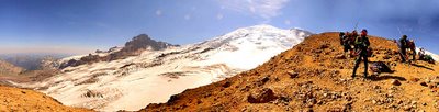
As always, we do our best to update the current route and climbing conditions. Climbers on Mt Rainier are focusing on the Emmons, DC, Kautz and Tahoma Glacier these days. If you're hiking to Camp Muir, check out the latest Muir Snowfield conditions,and if you are headed to Schurman, watch for ice on the Inter Glacier.
As always, we do our best to update the current route and climbing conditions. Climbers on Mt Rainier are focusing on the Emmons, DC, Kautz and Tahoma Glacier these days. If you're hiking to Camp Muir, check out the latest Muir Snowfield conditions,and if you are headed to Schurman, watch for ice on the Inter Glacier.
Close calls...
A guided team took a significant crevasse fall near 13,600 feet on the Emmons last week. No one was "seriously injured." however, one climber reportedly fell 50 feet and broke a few teeth (ouch!) The team self rescued and descended the mountain under their own power. The crevasse opened up somewhat out of nowhere. One climber commented that "Of all the crevasse crossings on the route, this one seemed more solid than others."
And today, another climber struck his head while successfully dodging rockfall on the Disappointment Cleaver. He too was able to walk off the mountain with some help from other climbers. A few close calls, yes, but the fact remains that there have been no major rescues or injuries this year. Some would prefer that I "whisper" this fact, or "knock on wood" when stating it... but I'd prefer to remind everyone how well the season is going, and to thank those who have climbed for making this year safe "so far."
It reached 74 degrees at Paradise today. We've had close to 7,800 climbers attempt the summit this year; the success rate is hovering around 64%.
The Summit
Yet another weekend of great weather! We've updated the Tahoma, DC and Emmons conditions. The routes are holding together nicely, which should make for great climbing in Sept.
On Sunday, the summit was AMAZINGLY warm and calm. We spent a good 4 hours on top, and there was NO wind to speak of.
There is an interesting change on Columbia Crest, however... Has anyone noticed that big crevasse forming on the actual summit??? There is a large crack that is getting wider each week. I wonder if Mt Rainier will hold onto its 14,410/11' status if this keeps up... There seems to be a LOT of rock exposed too... The crater, however, is filled w/ snow. More images soon.
Watch the crevasse crossings...
The weather looks promising for the weekend. There is very little news to report in what is most thankfully becoming a very, very quiet summer.
On the safety side of things, climbers should be prepared for dangerous crevasse crossings. We have reports of dicey bridges on the Emmons, DC, and Kautz routes. Avoiding a catastrophic crevasse fall could mean finding an alternative route around the hazard, or using protection and belays. Most teams simply follow the established boot path, which doesn't always offer the safest or best climbing line. We often find that the glaciers and crevasses change rapidly after weeks of sun and heat. So be prepared to deviate from the boot track if you want to safely reach the summit...and return!
On the safety side of things, climbers should be prepared for dangerous crevasse crossings. We have reports of dicey bridges on the Emmons, DC, and Kautz routes. Avoiding a catastrophic crevasse fall could mean finding an alternative route around the hazard, or using protection and belays. Most teams simply follow the established boot path, which doesn't always offer the safest or best climbing line. We often find that the glaciers and crevasses change rapidly after weeks of sun and heat. So be prepared to deviate from the boot track if you want to safely reach the summit...and return!
Seafair and the Perseid Meteor Shower
It was Seafair in Seattle last weekend (AKA MASSIVE boat party on Lake Washington.) For some, "Seafair" means "Let's get out of town." And if you were in that clique, Mt Rainier provided a pretty good place to avoid: 1. the heat, 2. the traffic, and 3. the hydroplane chaos... but not 4. the Blue Angels, who managed to buzz around the mountain a few times. By comparison to the scene around Lake Washington, The Mountain wasn't such a bad place to be. The freezing level topped 14k and there was little wind!
It's getting to be that time of year when many of the non-standard routes really start to fall out of shape. Most climbers turn their attention to routes like the DC, Emmons, Kautz and Tahoma Glacier...
On the astronomy front, the upcoming weekend marks the height of the Perseid Meteor Shower. The annual light show peaks around August 12th, but you can view an increased number of meteors throughout the week. If the weather is clear (and the moon or city lights aren't too invasive) observers can often view 30-60 meteors per hour! The best part for climbers? You don't need a scope or binocs! If you've the extra time, it's worth spending a night at high camp just to check it out.
Edmunds Headwall and Romance
A pair of climbers took on the Edmunds Headwall last week. They opted for the climbing line after witnessing a fair amount of rockfall off Ptarmigan Ridge and Mowich Face... It seems that the west face of Mt Rainier is melting rather quickly.
 On the fun side of things, I found this. It seems that romance for the broken hearted is alive and well on Mt. Rainier. According to Seattle author and dating maven "Breakup Babe" (AKA Rebecca Agiewich,) climbing could be good for your personal life (or not)! Of course, you’d have to read the book to find out how and why. But one fan was compelled enough to carry his copy to the summit. Maybe Ms. Agiewich will send us her Rainier trip reports for public consumption???
The weather looks quite good this weekend; the standard routes seem to be in good climbing shape.
August Climbing
Things have cooled off substantially over the past few days (I saw spitting snow at Camp Schurman this weekend) which was great news for those folks who were climbing the standard routes. The high freezing levels and sun over the past few weeks, however, have had intense effects on diminishing the mountain snowpack. Cleavers like Tahoma, Success, and Kautz are mostly melted out... So are Liberty and Curtis Ridge.
That said, climbers are enjoying good climbing conditions on the Kautz Glacier, Disappointment Cleaver, Emmons Glacier AND Little Tahoma. For the most part, the success rate has been high. Also of note is a traverse of the Tatoosh Range, and a trip report on Sluiskin Peak (over on cc.com).
As a curiosity, there have been over 6,000 registered climbers (total) for Mt Rainier in 2006. The success rate is hovering at 62%. What's most amazing is the fact that we have not seen one significant injury or rescue!! What an accomplishment!
Mat Goodyear - Oct 28, 1969 - July 19, 2006
In the fall of 1998, I boarded a plane in Boston bound first for London, and then to Edinburgh, Scotland for graduate school at the University of Edinburgh. While an undergrad at the University of Maine, I lived and breathed the life of a typical male, American, college student: I played baseball, drank beer, chased women (mostly unsuccessfully), studied journalism with the hope that someday I'd
Smooth Sailing on Mt Rainier
 The good news, is that we have NO news. Other than a spate of warm weather (i.e. HOT WEATHER,) things remain consistantly quiet on the mountain.
 Climbers have been successfully reaching the summit via the "standard routes." Most teams that are in good shape are doing so quite easily and w/o incident. There is an extensive Emmon's trip report here. We're keeping the "current climbing conditions" as up-to-date as possible, with new reports on Ptarmigan Ridge and Russell Cliffs.
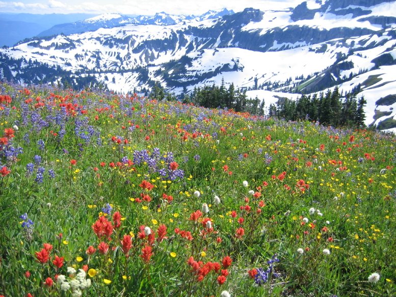
As an aside, the wildflowers in the meadows are fabulous. This image is from Eric Hamel of the NPS.
Hot, Hot, Hot
The temps are soaring in Washington, and gaining altitude on Mt Rainier is one way to avoid the heat. The last two weeks of July and the first two weeks of August historically mark the highest success rates and most reliable weather for the peak. If you're climbing, leave early, as the freezing level is hovering around 15,000 feet.
 Recent mountain achievements include Jason Edwards personal climbing benchmark. Jason successfully made his 300th summit climb of Mt. Rainier on July 12th. Jason joins an elit clan of guides (there are only 6) who have more than 300 summits. The current summit record is held by George Dunn, who has over 480 successful ascents.
In other news, we've updated the route condition reports for the Kautz, DC, and K Spire to name a few. Please keep the updates coming.
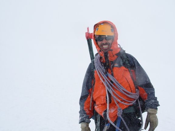 Recent mountain achievements include Jason Edwards personal climbing benchmark. Jason successfully made his 300th summit climb of Mt. Rainier on July 12th. Jason joins an elit clan of guides (there are only 6) who have more than 300 summits. The current summit record is held by George Dunn, who has over 480 successful ascents.
 In other news, we've updated the route condition reports for the Kautz, DC, and K Spire to name a few. Please keep the updates coming.
"Primo" time to climb
Summer is in full swing. Warm temps and mostly clear skies have been generous to climbers and the forecast looks promising.
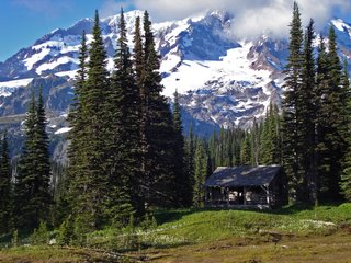 The snowpack is rapidly melting, which allows for quick and easy access to the alpine. Most of the Wonderland Trail, for instance, has melted out (save Panhandle Gap area.) The meadows are in full bloom, yet the upper mountain still has a fair amount of winter snowpack. Time to climb...
We've posted updated Mt Rainier climbing conditions on the Emmons, Tahoma, DC, Ptarmigan Ridge and other routes... If you've some reports, please pass them along.
PARADISE CONSTRUCTION UPDATE
A shuttle system is now assisting visitors along the Paradise Valley Road and those who park remotely at Longmire and Cougar Rock. The shuttle is free of charge and will operate Friday – Sunday and Labor Day through September 10th. See the Access and Roads page for more information.
Pushing up the bar
So, what will YOU be doing at age 83? If you're Bill Painter, you're still climbing Mount Rainier. Mr. Painter of Richland, WA successfully ascended the Kautz Glacier route this weekend with his family and friends.
He described the climb as his "most technical so far," but when I asked how he was feeling afterward, Bill's response was, "I feel fine today, but I sunburnt my lip a little." For training, Bill (a self described "family man") rides his bike at least 100 miles each week and regularly hikes a local hill called Badger Mountain... Actually, he makes that hike quite a bit... 1,502 times to be exact. But most of all, he credits his fitness to a life of hard work. Congratulations, Bill Painter!
Are you interested in climbing Ptarmigan Ridge or routes on the Mowich Face?? Make sure you register at the Carbon River Ranger Station. Remember, the Wilkeson Ranger Station is PERMANENTLY CLOSED. A number of teams have been turned around b/c they didn't get permits. See the registration page for specific and helpful information about registering for these routes.
So far, so good. Keeping it safe on Mount Rainier
"Accident-wise," things have been REALLY QUIET on the rescue front. We've had a few minor issues, but nothing too serious. One frustrating event did occur this weekend that required our attention. A climber took 15 hours to reach Camp Muir (with the help of his partner and the climbing rangers). Yup, 15 HOURS. OK, so he said he wasn't going to climb, but two days later, the Camp Muir ranger was notified about two climbers having an argument at the base of the Disappointment Cleaver. Seems the faster partner couldn't handle the stumblingly-slow pace and decided no ascent was better than a 24 hour one-way ascent. The tenacious one, however, continued uphill at a snails pace until guides and rangers convinced him otherwise.
We've also seen a number of folks show up at Camp Muir without the proper overnight gear. A climber at Camp Muir sent me these observations, I wanted to share them.
As for climbing info... I'm trying a new format on the Updated Climbing Conditions page... Otherwise, send me your comments and images. I want 'em... :)
We've also seen a number of folks show up at Camp Muir without the proper overnight gear. A climber at Camp Muir sent me these observations, I wanted to share them.
"Just a quick comment about our stay at Camp Muir. It always amazes me how many people... show up at Muir... with no tent. We saw this Thursday night when a group of 4 arrived at the public shelter. Problem was, the shelter was full. They became a bit indignant and fortunately for them, the ranger helped them putIt seems odd to actually have to say this in 2006, but please, BRING the proper equipment and KNOW how to use it.
together a lean-to from scrap lumber behind the shelter... so they weren't exactly out in the elements (I'd have told them to go back to Paradise)."
As for climbing info... I'm trying a new format on the Updated Climbing Conditions page... Otherwise, send me your comments and images. I want 'em... :)
Keeping up... 83 year old makes summit bid
The climbing season is rolling along nicely. Today, an 83 year old started a summit attempt via the Kautz Glacier and he's no stranger to Mount Rainier. Bill Painter of Richland, WA holds the record as the oldest person to summit the mountain (both in 2004 and 2005). Last year, he smoothly ascended the Emmons Glacier... More on his attempt early next week.
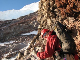 It's been 3 weeks since I've been in the park... Thankfully, some of the climbing rangers have been helping w/ route and condition updates. That said, we still love your climbing reports. Over the next day or two, I'll upload many of the great reports climbers have been sending. Of significant news was an ascent of Willis Wall, Mowich Face and new information on Kautz and Success Cleavers. Photo by Loren while on the Willis Wall. YIKES!!!
 It's been 3 weeks since I've been in the park... Thankfully, some of the climbing rangers have been helping w/ route and condition updates. That said, we still love your climbing reports. Over the next day or two, I'll upload many of the great reports climbers have been sending. Of significant news was an ascent of Willis Wall, Mowich Face and new information on Kautz and Success Cleavers. Photo by Loren while on the Willis Wall. YIKES!!!
The skiers are taking over!
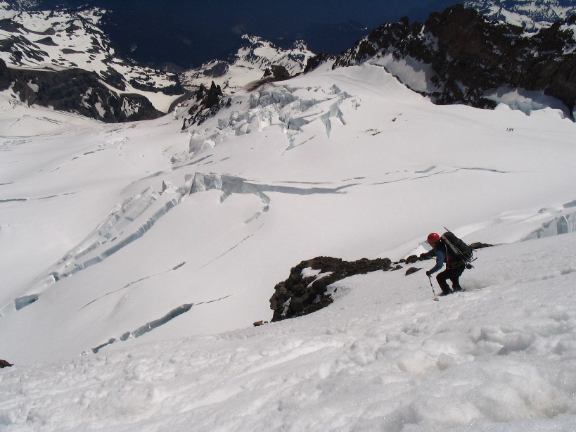 New snow and warm temperatures this final weekend in June brought out the most skiers I have ever seen on Rainier. The DC, Emmons, Winthrop, and Fuhrer Finger were all skied. The ski conditions were great for the most part. The snow was firm but somewhat punchy down to 13,000 feet. Conditions improved as the snow softened and became less wind- affected. There was good corn skiing from about 11,500' to about 10,000'. The snow became heavy and wet below that altitude. Above is a photo of one of those skiers descending the Cleaver. Although the skiing can be fabulous, be realistic about conditions and your ability, and be sure to be "on your game", as exposure to cliffs below can severely impact your outing in the event of an uncontrolled slip!
Conditions and weather have combined this week to give us stable weather and great climbing. Climbers summitted via the Disappointment Cleaver, Ingraham Direct, Fuhrer Finger, Kautz Glacier, Tahoma Glacier, Liberty Ridge, Winthrop Glacier, and the Emmons Glacier. Of course, the warm weather has its downside: rock fall and ice fall have increased exponentially, and a few routes have started to melt out... notably Gibralter Ledges, which had seen quite a few ascents this year.
--Adrienne Sherred - Photo by Andy Anderson
Little new to report...
Updated conditions are posted, but other than hearing "we made the summit via ?X?X? route," most things seem to be straightforward.
I've been getting a number of climbing reports, with most climbers commenting on the weather conditions they experienced. Although we appreciate this, it is even more useful for prospective climbers to receive comments on snow/ice conditions and crevasse situations, since these don't generally change quite as fast as the weather! For the most part, it seems that many of the standard routes are in fine climbing shape. As always, weather and conditioning are key factors in whether you summit or not.
I've been getting a number of climbing reports, with most climbers commenting on the weather conditions they experienced. Although we appreciate this, it is even more useful for prospective climbers to receive comments on snow/ice conditions and crevasse situations, since these don't generally change quite as fast as the weather! For the most part, it seems that many of the standard routes are in fine climbing shape. As always, weather and conditioning are key factors in whether you summit or not.
Mt Rainier Route Conditions - June
 The weather turned nice last weekend and climbers wasted no time in snatching up this opportunity. Routes that melted out earlier this spring are back in shape and looking great! Climbers had successful ascents on:
The climbing conditions are great. In the colder part of the day the snow is firm and supportive making for excellent cramponing. By mid- morning it has been soft enough to make the trip down a little less jarring. From everything I saw up there this weekend and from all the reports that we heard most of the routes are very straight forward and direct. Obviously there are a few route finding challenges, but that's what makes it fun, right?Liberty Ridge, Ingraham Direct, Disappointment Cleaver, Emmons Glacier,
Kautz Glacier, Fuhrer Finger, Gibraltar Ledges and Gib Chute to name a few.
Skiers were making us all jealous up there as well. I saw quite a few people taking advantage of the softer mid-morning and early afternoon snow. Several intrepid skiers and boarders made turns down the Ingraham. Those big sweeping turns sure are fun but that speed has the downside of letting things like crevasses and ice cliffs sneak up on you really fast. So remember to scout out your ski routes before you start ripping down the hill. A great way to do this is to climb up what you plan to ski down.
~ Andy Anderson and Mike Gauthier
Paradise Construction and Parking
Here is a quick note on trail access. Due to the construction the normal access to the Paradise trail is blocked off. The best place to start your hike to Muir or anywhere else on this side of the Mountain is from the west end of the parking lot at the Jackson Visitor Center on the Dead Horse Creek Trail. It links up with the normal Skyline trail in about 1 mile and will save the hassle of walking around the construction fencing.
As a reminder, if you plan to depart from Paradise while climbing this summer, arrive before 9 a.m. The Paradise construction project has displaced most of the overnight parking. Once the Paradise picnic area melts out, ALL overnight parking should take place there. Immediate parking spaces at Paradise will be very limited. If you show up late, you could end up parking along the Paradise Valley Road. Depending on how far, you may need to take the shuttle.
This image of a climber on the Nisqually Cleaver is by Erik Jacobson
Fewer climbers?
As noted earlier, there has been a downward trend in the number of climbers attempting Mt Rainier's summit. From October 1st, 2005 to June 1st 2006, there were 871 registered climbers (and that included RMI stats.) During the same period the preceding year, there were 945, and that DID NOT include RMI stats.
There has also been an increase in reservations. Be advised that most of the Friday and Saturday night reservations have been taken for this season. If you want to climb a primary route, try climbing between Sunday and Wednesday.
There has also been an increase in reservations. Be advised that most of the Friday and Saturday night reservations have been taken for this season. If you want to climb a primary route, try climbing between Sunday and Wednesday.
Skiing Mount Rainier
 There is nothing totally new about skiing Mt. Rainier. Sure, it's not done that often, but people do ski and ride it... However, skiing the Wilson Headwall is something special. The recent snowfall is settling nicely in some areas. Climbers-turned-skiers (or are they skiers-turned-climbers?) are making their moves on Rainier's slopes. Ski, board, and snowpack reports are welcome!
As for the internet... this blogger site has its down days... But that's ok, because it's easier to express frustration at an internet site, than say, well... we'll just move on...
A few "climbing instigators" have been sending GREAT route conditions information. I've been trying to dump most of it directly into the blog. But as the amount of information grows, I wonder if it would be easier to have a bullentin board?
Please send me your thoughts? I'm very pleased that you are willing to share their experiences! Everyone REALLY appreciates it!
Image by Sky Sjue, just before he drops down the Wilson Headwall...
Camp Muir and Paradise
 The mountain theme last weekend was snow... and lots of it. Here is an image of Little Tahoma taken by Joe Puryear on Saturday at Camp Muir when the weather cleared. The photo below, however, better represents the weather conditions.
A few teams took a stab at the Disappointment Cleaver, but all turned back over avalanche concerns. The lower portion of the cleaver has a history avalanche, and there were plenty of unique layers in the snowpack to draw some concern from both guides and climbing rangers. Over the past few weeks, the mountain has received at least a two feet of new snow. In many places, there is more due to wind transport. Joe will post some route images and conditions tomorrow.
 One quick tip: the Muir Snowfield is in EXCELLENT shape for skiing/boarding, especially now that the wet weather has backed off for a few days.
PARADISE CONSTRUCTION
This weekend, some climbers experienced a few issues regarding construction at Paradise. Most of the upper parking lot is fenced off, which greatly limits the number of parking spaces. On Saturday and Sunday, the parking lots filled REALLY early. We strongly suggest that you arrive early if you want to find parking close the Jackson Visitor Center.
When the Paradise Picnic area melts out, all people planning to park overnight will need to park there. We'll provide more information on the Paradise situation when we have some maps and more to share. Stay tuned...
Liberty Ridge and Blogger...
 The "Blogger" software is giving me grief today... I'll do an update when possible, but it seems that site has been down most of the morning...
 I was able to slip in some info on Liberty Ridge. The image is from Chris Nunzir, his team was on the route for a number days during a storm, but did get one nice sunrise.
Mt Rainier Route Photos
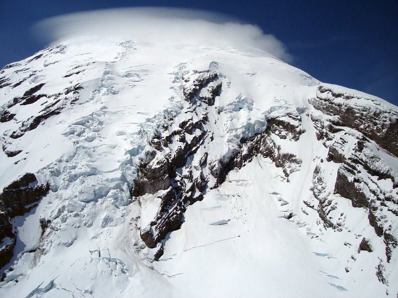 The heavy snowfall from last week slowed a number of teams, many have not made the summit. Since we're lite on route conditions, I'll share these recent climbing route photos. Here is the Nisqually Cleaver taken on May 30th.
 There are a number of climbers at Camp Muir this weekend, none have reported successful ascents. One Seattle party spent 15 hours pushing the route in from Camp Schurman, while another team summited on Liberty Ridge Thursday/Friday. The "Liberty" team took quite a bit of extra time and had to spend at least one night on top... They radioed from Camp Schurman on Saturday to report that one member had 7 digits with frostbite! We remind climbers not to underestimate how physically difficult it is to climb Liberty Ridge.
Photo by Mike Gauthier
Aerial Mount Rainier, Climbing Route Images
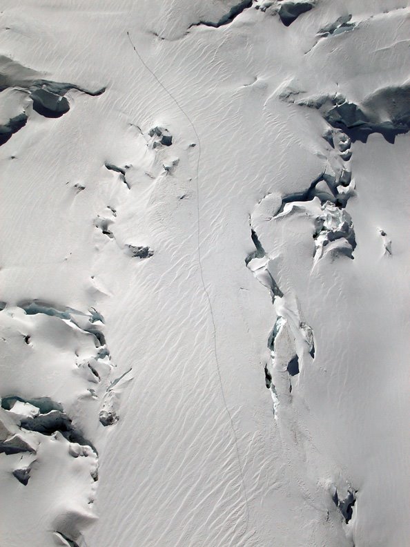 Moving the bear aside... This picture tells a long story. Here is Mount Rainier on May 30, 2006. I was able to capture a few climbing route images during a flight.
A series of recent storms dumped a lot of snow on the mountain. In some places, there were reports of 3 feet. There are rumors that more is expected later this week too. Winter is not over...
Today, however, climbers contended with blue bird skies and light breezes (and quite a bit of postholing.) The tracks indicated that a few made the summit too! Here, two climbers took on the arduous task of breaking trail up the Emmons Glacier... It didn't appear as if anyone else was on the route either. These climbers are at roughly 11,400 feet, exiting the top of the corridor to the left.
Parties were having a hard time making it to Camp Schurman until Sunday, so it's good to see a team getting up the route. This may mark the first successful ascent of the route in 2006.
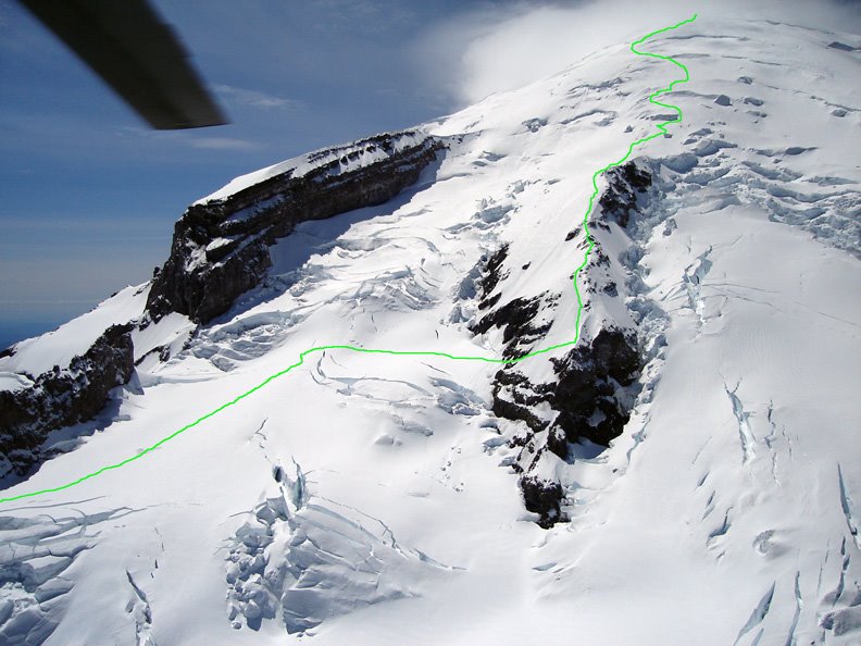 And here is a nice image of the Ingraham Direct and Disappointment Cleaver routes. The green line traced the visible climbing route up the Disappointment Cleaver. Notice how directly it climbs the spin of the cleaver... Nice...
More images later, this week. All images by Mike Gauthier
Subscribe to:
Posts (Atom)