Non-Lockers vs. Lockers at the Master Point

At a beginning level, climbing tends to be rule-based. These rules that you are provided at the start of your career are important. They will help to keep you safe.

It should be noted that once you have a few years of experience, there is some room to re-evaluate some of the rules. However, this should only take place after you have climbed with a lot of different experienced people.

One of the commonly quoted rules for toproped climbing is that one should always use two opposite and opposed lockers at the master point.

Two opposite and opposed lockers.

The idea is that there is no way that the rope could possibly jump out of two opposite and opposed lockers. And while it may be possible -- however unlikely -- for movement in the system to cause the one of the gates to become unlocked and to open, it would be nearly impossible for the both lockers to become unlocked and to be opened.

In the guiding world, two opposite and opposed lockers are considered to be industry standard. The liklihood of a single locking carabiner becoming unlocked and opening is incredibly low. However, this is one of the rules that you learn when you start to climb and it has become so integral to outdoor groups throughout the world in toproping that it has become the industry standard across the board.

Industry standard is one of those phrases that we should pay attention to in climbing. There are very few things that can be considered industry standard in the climbing world.

That said, it is incredibly unlikely that a single locker in a toprope system will fail. But what if something does go wrong? And what if you were toproping in a way that was outside this standard? Certainly you would feel terrible, and not only that, you would also be hammered by the internet forums, the blogs, and the magazines for doing something considered to be outside the norm. As such, it's probably a good idea to stay within the norm.

Many climbers use two opposite and opposed non-lockers in lieu of two opposite and opposed lockers. Two opposite and opposed non-lockers should be considered the equivalent of one locking carabiner. For non-lockers to have equivalency to two opposite and opposed lockers, there must be three opposite and opposed non-lockers.

Three opposite and opposed non-lockers and equivalent to two opposite and opposed lockers.

Rules in climbing exist to create a wide margin of safety. There's really no reason at all not to have a wide margin of safety in a toproped environment.

--Jason D. Martin

September and October Climbing Events

--September 2 -- Golden, CO --Book Presentation: Fun Climbs Colorado: Best Family Climbing Vacations

--September 4 -- Morrisville, NC --Climbing Team-Open House

--September 5 -- Great Falls National Park, VA --Great Falls Adopt a Crag

--September 5 -- Red River Gorge, KY --Mountain Gear UClimb

--September 9 -- Boulder, CO --Flagstaff Trash Bash

--September 11-13 -- Pine Mountain, CA --Pine Mountain Pulldown

--September 12-13 -- Pocatello, ID --Pocatello Pump

--September 12 -- Grand Canyon, AZ --Grand Canyon Clean Up & Climb

--September 12 -- Morgan County, TN --10th Annual Obed Wild and Scenic River Adopt a Crag

--September 12 -- Sand Rock, AL --Sand Rock Adopt-a-Crag Trail Day

--September 12-13 -- Tettegouche State Park, MN --North Shore Adopt-a-Crag

--September 17-20 -- Salt Lake City, UT --8th Annual Climb4Life Salt Lake

--September 18 -- Oakland, CA --Touchstone Bouldering Series 5: Great Western Power Company

--September 19 -- Smith Rock State Park, OR --1st Annual Smith Rock Fall Thing

--September 19 -- Castlewood Canyon State Park, CO --2009 REI Adopt a Crag at Castlewood Canyon State Park

--September 19 -- Red Rock Canyon, Colorado Springs, CO --Summer Sandstone Series: Red Rock Canyon Climbing Comp and Clean-Up

--September 19 -- Devil's Tower National Monument, WY -- Devils Tower Adopt-a-Crag Trail Day

--September 19 -- Yellow Springs, OH --Adopt a Crag. Clean & Climb: John Bryan State Park

--September 22 -- Harrisburg, PA -- Climb Kilimanjaro: A Kids with AIDS Benefit

--September 23-27 -- Yosemite National Park -- Yosemite Facelift

--September 26 -- Carderock, MD --Carderock: Adopt a Crag

--September 25-27 -- Jasper, AR --24 Hours of Horseshoe Hell

--September 26 -- Indian Creek, UT --National Volunteer Day For Public Lands

--September 26 -- Ferguson Canyon, UT --Adopt-A-Crag: Ferguson Canyon

--September 26 -- Flagstaff, AZ --Adopt-A-Crag Day at the Pit

--September 26 -- Muir Valley Nature Preserve, KY --Friends of Muir Valley Annual Trail Day

--September 26 -- Harrisonbrg, VA --Hidden Rocks Trail Day

--September 26 -- Little River Canyon, AL --Little River Canyon Clean Up

--September 26 -- Upper West Bolton Cliff, VT --Upper West Trail Day

--September 26 -- Portland, OR --PDX Ice Fest 2009

--September 30 -- Golden, CO --Pictures From Space, Taken from the Camera of the Late Bradford Washburn

--October 1 -- Indian Creek, UT --International Climbers' Meet

--October 2-4 -- Clifton, ME --1st Annual Clifton Climber's Weekend Service Project

--October 3 -- Horsetooth Resevior, CO --14th Annual Horsetooth Hang

--October 3 -- Coopers Rock State Forest, WV --Coopers Rock Adopt a Crag

--October 3 -- City of Rocks, ID --Moondance at the City of Rocks

--October 9 -- Salt Lake City, UT --Craggin' Classic 2009

--October 9 -- Slade, KY --Rocktoberfest

--October 23-25 -- Joshua Tree, CA --Climb Smart 2009

--October 24 -- Chapel Hill, NC --2009 Reel Rock Film Tour

Weekend Warrior -- Videos to get you stoked!

It is that time again. Time t0 throw off the suits and ties (or whatever you wear to work) and dawn our respected suits of outdoor armor. Whether it be shorts and t-shirt for some classic cragging or the full-on gore-tex tux for some hardcore alpine endeavors...whatever you wear the important thing is getting out there and playing outside. To help you get psyched we've got a few great videos for you.

The first is the trailer for the seldom seen classic climbing movie "Take it to the Limit". I watched this last night and was simply amazed at the filmmaking and acting quality. If you haven't seen it yet, watch it and be prepared to laugh...a lot!


The second video is from another classic piece of climbing cinema, "Cliffhanger". Whenever I see footage from this movie I was wonder what type of impact Sylvester would have had on the climbing world if he hadn't went the Hollywood route. I mean, you can't fake this footage...right?


And last but certainly not least...Vertical Limit! This film is quite possibly Chris O'Donnell's finest work...which I realize isn't saying much (I apologize ahead of time to all three of his fans). After all, only the best of the best could pull off the high flying chasm jump at the end of this trailer, talk about shoulder and grip strength!


An Adventure on Mount Slesse

Alex Lowe once said that the best climber is the climber that is having the most fun. When I put together personal climbs, it's important to add the ingredients that will lead me to such a place. And for me those ingredients are the right people.

Brian Eckerling and Jay Hack both worked as guides at the American Alpine Institute for a number of years. We all started guiding together in the summer of 2000. And since then, the three of us have done a number of routes together. We've done two walls in Zion and a lot of climbing in Red Rock Canyon. I've done some of my most memorable climbs with those guys and have had a lot of fun with them as well.

Brian and Jay both grew up a few years ago and got real jobs. I, on the other hand, am still deeply entrenched in the guiding world. Brian is now a massage therapist and anxiously awaiting the birth of his first child. Jay is now a financial manager and a serious weekend warrior.

I've long dreamed about the Northeast Buttress of Mount Slesse. This Grade V route in British Columbia requires 25 pitches of climbing on an absolutely stellar feature. The route was prominently featured on the most sought after tick list in the country, Fifty Classic Climbs of North America. And while the route is not considered technically difficult (depending on the variation, the line goes from 5.9-5.10a), the overall experience is considered extremely difficult because the route is so long and the descent is so serious. Jay and Brian were both up for the adventure, so we grabbed our passports and made our way to Canada.

While this is an incredible objective, an ambiance of dread hangs over Mount Slesse that has nothing to do with climbing. The peak was the site of the worst air disaster in Western Canada's history. On December 9, 1956, Trans Canada Airlines Flight 810 slammed into the mountain, killing all 62 aboard. For five months nobody knew what happened. Finally on May 10, 1957, a female mountaineer named Elfrida Pigou discovered the crash site. The discovery set off a stampede of treasure hunters and collectors. It wasn’t until May 25, 1995, that the BC government placed a protective zone around the debris field, declaring it a Heritage Wreck Site.

I took the following photo of a memorial marker after we finished the climb.

The Mount Slesse Memorial Plaque. Click on the photo to enlarge.

We left the car at three in the morning on the first day of the climb. After about two and a half hours of hiking we made our way to the "Propeller Carin," a place where some airplane debris, including an old propeller have been propped up in the rocks. From this spot we could see our objective.

Brian and Jay under the route. The Northeast Buttress is the prominent ridge in the background.

Many consider a small pocket glacier below the start of the route proper to be one of the greatest objective dangers. The seasonal glacier is fed by the snow and ice that is shed off of the mountain's east face. It collects on steep slabs beneath the face and the northeast buttress. During the summer season, the ice in this glacier is very unstable and is constantly breaking up. It could easily rain truck-sized blocks down on an unsuspecting climber crossing beneath it. The whole feature usually slides sometime late in the summer.

Luckily, by the time we arrived, the pocket glacier had almost completely slid away. Only a small relatively stable remnant of the glacier remained beneath the east face when we arrived.

A Party on the Slabs Below the Route at Dawn

Jay beneath the remnants of the pocket glacier at the base of the route.

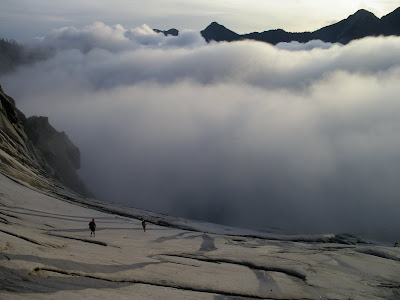
A Beautiful Sunrise as seen from the Slabs beneath the Route
with the Illusion Peaks above the Clouds


The bottom of the route requires one to climb easy but exposed terrain. Some of the climbing at the base of the route is on good rock, but some is vegetated and muddy. Fog around the mountain early in the morning made everything a bit damp.

Brian on Easy Terrain low on the Route

Brian on the First 5.7 Pitch on the Route

Amazingly, some of the most dangerous sections of climbing were on the "easier" sections. Even some of the pitches midway up the mountain included wet grass and mud.

Brian Climbing through Vegetation Mid-Route

Down low, we were trying to figure out what gave the route such a classic bearing. It turns out that on the last third of the route, the climbing is quite good. Indeed, it is not just the climbing that is good, but the whole experience. Some pitches move up classic features, whereas others are in stunning positions high above the valley floor.

A Classic Lie-Back Corner

Approaching the Upper Mountain

Brian on Pitch 17

Jay Leading the Final Pitches

Jay Eating a Sandwich just below the Summit

We finally summited at about six in the evening. We expected the descent to be difficult, but at that time we still had no idea what we were in for.

Almost immediately we dropped down off the summit and began to work our way down through a series of mildly sketchy loose gullies. After downclimbing and rappelling, we eventually found ourselves benighted in a talus strewn basin.

Descending in the Alpenglow

Rigging a Rappel at Dusk

We weren't the first climbers to have problems with the descent from this peak. In the past, climbers accessed the route via Nesakwatch Creek Road on the east side of the mountain and then descended to Slesse Creek on the west side. In other words, you needed two cars or a long bike ride back to the other side of the mountain, neither of which are very appealing options after a big climb.

We were supposed to descend via a new descent route that the books and the Internet all refer to as "the Crossover Pass" descent. The value of this descent route over the other options is that one does not need to descend to the opposite side of the mountain to a car or a bike, but instead may descend back to the route's access trail.

Due to the fact that this particular route wasn't terribly well traveled and the fact that it was nearly pitch black out, the three of us decided to bivy. We didn't have sleeping bags or tents or any real camping gear at all. But it wasn't really safe to keep moving. And while it is fun to look back on this as a great bonding experience, it was really really cold. We absolutely could not wait until the sun finally peaked its head out above the mountains to rewarm us. Indeed, in the morning I think all three of us understood why the ancients worshiped the sun.

After the sun shook the cold out of our bones, we got moving again at about six in the morning.

Jay Early on the Second Day of the trip with the American Boarder Peak
and the Canadian Boarder Peak in the Background


Mount Slesse from our Descent. Our route climbed the middle of the face.

The Crossover Pass descent turned out to be a little bit epic. We had this description to work with. The description breaks down the route-finding into two "Crux Route-Finding Sections." The first crux route-finding section was easy. The second however, dropped us into another loose gully. The notes in the description were off and we ended up abandoning a handful of cams while dodging rockfall to get safely down.

The final crux of the descent involved a steep downclimb through thick and slick vegetation. There was supposed to be a trail in the woods somewhere, but we never found it. This element of the descent felt as if it took forever.

At one point, I slipped on the steep huckleberry bushes and slid down the hill a few feet before I came to a stop. Brian slipped in the same spot and then so did Jay. For a moment it was kind of funny...that was the moment before we realized that we had upset a bee hive. Then it wasn't so funny anymore.

We immediately stumbled, slid and ran away from the spot where we were getting nailed by bees. I got stung three or four times, Brian got it five or six times, and Jay got the brunt of it with dozens of stings. Luckily, none of us were allergic.

When we finally emerged from the woods, we were exhausted, but happy. We knew that the remainder of the trek back to the car would be on a trail and would be relatively easy.

Brian and Jay in the basin below Slesse after escaping the bushwack

The soul of climbing is not in the routes that we climb or in the places that we visit, but instead in the friends that we make. Mount Slesse gave us a cool route in a great setting, but that's not what made the trip great. Instead, it was spending some good time with some good friends while on a great adventure...

--Jason D. Martin

Cascade River Road Closure

AAI just received the following schedule from North Cascades National Park and the Mount Baker-Snoqualmie National forest concerning the road closure on Cascade River Road. This is the road that climbers and hikers use to access Eldorado Peak, Boston Basin, Cascade Pass and the Ptarmigan Traverse.

1. Aug 31 - Contractor mobilizing
2. Sept 1 - Tuesday - Contractor closes road to ALL from 7 am to 6 pm - Emergency traffic may or may not be able to get through if cranes are set up.
3. Sept 2 - Wed. - Contractor closes the road to ALL from 7 am to 6 pm - Emergency traffic may or may not be able to get through if cranes are set up.
4. Sept 3 - Thursday - Contractor closes the road to ALL from 7 am to 6 pm - Emergency traffic may or may not be able to get through if cranes are set up.
5. Sept 4 - Friday - Road is open to ALL - Contractor can work if he wants to but at this time has said he will not.
6. Sept 5 - 6 - 7 - Labor day weekend Sat - Sun - Mon - Road is Open to ALL with no restrictions
7. Sept 8 - Tuesday - Road closes to ALL until Oct 15 or there about. No exceptions so don't be caught east of the bridge.... Emergency traffic may not be able to get through if cranes are completely set up.

Climbing News from Here and Abroad -- August 27, 2009

Northwest:

--A diver is missing and presumed dead after a scuba diving accident off Orcas Island. Authorities told news agencies that Michael Scherner, 40, disappeared on August 12 while scuba diving with a friend. Michael was well known in the climbing community. He recently moved to Bellingham from Utah where he frequently climbed in Little Cottonwood, Bells Canyon, the Needles district of the Canyonlands and in Provo Canyon. Michael was involved in the construction of climbing gyms in both Utah and Colorado. To read more about the scuba diving accident, please click here.

--An experienced Portland outdoorsman went to great efforts last week to save his injured climbing partner, quickly hiking over three glaciers to get help in a feat that amazed a park ranger. Rodney Sofich and Chad Anderson, both 36-year-old Portlanders, were climbing the Dorado Needle in North Cascades National Park southeast of Bellingham, Wash., on Monday when the accident happened. To read more, click here.

The cougar that has been harassing mountain bikers in Leavenworth has been shot.

--A farmer who killed an aggressive cougar that was threatening hikers and mountain bikers on Freund Trail near Leavenworth is just happy to have saved his pig. The cougar was in the process of attacking one of the man's pigs when it was shot. To read more, click here.

--Oregon Live has recently published a story about a dentist who suffered a serious fall on Mount Hood a few months ago and how his recovery is going. To read the story, click here.

--U.S. Senator Maria Cantwell (D-WA) recently applauded passage of the Hoh Indian Tribe Safe Homelands Act, in the Senate Indian Affairs Committee. The bill would transfer approximately 37 acres of land owned by the National Park Service to the Hoh Tribe, and would take into trust land the Tribe has purchased, or been given. To read more, click here.

Sierra:


--Inyo Search and Rescue has been busy this summer. In this last week the SAR team responded to two calls for serious cases of altitude sickness, one of which was fatal, and helped find a group reported overdue floating on the river. To read more, click here.


--A dead chipmunk has tested positive for plague in the Lake Mary area of Mammoth Lakes. he dead chipmunk was found near cabins in the Upper Falls tract. Debra Hein, Acting Safety Officer for the Forest Service, said that Mono County Health will post signs to keep the public informed. Health workers will do some surveillance next week to determine any further steps. To read more, click here.


--On August 20, a ranger in Yosemite National Park, along with National Park Service Agents, eradicated 4,735 marijuana plants found growing in the park. There have been a number of high profile "pot farms" found in the Sierra this season. To read more, click here.


Notes from All Over:


Mount Wilson in Red Rock Canyon at Dawn


--There are plans to raise fees for those who wish to climb and camp in Red Rock Canyon National Conservation Area just outside of Las Vegas. Public meetings to accept comments will be scheduled, and comments also are being collected by e-mail (redrockbp@blm.gov), fax (702-515-5023) or mail (BLM Southern Nevada District Office, Attn: Mark Tanaka-Sanders, 4701 N. Torrey Pines, Las Vegas, NV 89130). Comments may also be delivered to the Red Rock Visitor Center or the Red Rock Campground. The deadline for comments is Nov. 16. To read more, click here.


--The San Francisco Chronicle ran an op ed this week arguing that National Park fees should go up at parks throughout the country. To read the article and to comment on it, click here.

Conditions Report -- August 26, 2009

NORTHWEST:

--Forecast for the West Slope of the Cascades.

--Forecast for the East Slope of the Cascades.

--Webcam for Leavenworth and the Stuart Range.

--Forecast for Mount Rainier.

--Forest Service Road Report for Mount Baker-Snoqualmie National Forest.

--The Hannegan Road on the Mt. Baker Highway reopened on Aug. 5. This road gives access to many great mountains and hikes in the Mt. Baker Wilderness and North Cascades National Park.

--The Glacier Creek Road, which provides access to the north side of Mt. Baker, is currently closed to all public access while road crews work on clearing the debris blocking the road. This is expected to last until August 28 and any violators will be subject to heavy fines.

--The road to Artist's Point above the Mt. Baker Ski Area is now open. Besides providing access to some of the most amazing alpine scenery that you can drive to in the lower 48 it also provides access to the Lake Anne/Fisher Chimneys on Mt. Shuksan as well as the Ptarmigan Ridge and the Park and Mazama Glaciers on Mt. Baker. Click here for pictures of the road work.


The Easton Glacier on Mt. Baker. Photo by Kurt Hicks

--AAI Guide Kurt Hicks reported the following conditions on the South Side of Mt. Baker as of August 7, 2009:


A lot has changed on the Easton Glacier over the past three weeks. The amount of snow cover has decreased dramatically, resulting in much more dangerous travel conditions. The winter snow pack has melted off to about 6500', leaving blue glacial ice; the snow line was about 5000' a couple weeks ago, with a few feet of snow covering the ice. What a difference!

Travel conditions are tolerable. There are a number of crevasses between 8700-9000' that have sketchy bridges across them. Hidden slots abound, only marked by where someone has put a leg through--most of these bridges are not sagging an appear to be quite thin over cavernous cracks. The best plan is to start quite early and be back off the glacier well before noon.


--Mount Saint Helens, Mount Adams conditions and recreation report.


--An up-to-date ski and snow report for the Northwest may be found here.

--Up-to-date Pacific Northwest ice conditions may be found here.

--The Tieton River climbing areas have been closed for the season due to nesting raptors. To read more about this closure, click here.

--The Snow Creek Wall in Leavenworth is now open after a closure due to peregrine falcon nesting. The wall re-opened on July 15th. For more information and other conditions in the Okanogan-Wenatchee National Forest click here.

--We have recently received a couple updates regarding current Squamish conditions. Click here to read more.

--We received the following report regarding current conditions in the Bugaboos:

The following is a report from Tay Hason, Senior Park Ranger for BC Parks. A major rockfall event occurred yesterday (Aug. 11) that originated from above the climber's right side of the Bugaboo-Snowpatch Col. Coincidently, the old rap stations on the side of the col had been removed the previous day because of rockfall concerns. Also note that a new toilet was installed at Applebee to relieve the morning line-ups!

Rain initiated rock and mud slide on 090711 at approx 0900 hrs.

All rappel stations have been removed from the climbers' right hand side of the col. This rap route was established during a time when snow and ice covered the scree slope but currently presents an unacceptable rock fall hazard to climbers lower on the col.

Two chain stations have been added to the rap route on climbers' left allowing for 3-4 30m rappels over the bergschrund, or more safely, 1 double rope rappel to below the rock island and then another to well below the bergschrund.

Bugaboo-Snowpatch Col after the rockfall. Photo courtesy of ACMG/BC Parks

SIERRA:

--For information regarding wall closures due to falcon nesting in Yosemite National Park, click here.

--For an update on road conditions in the Eastern Sierra region. Follow this link to read more.

--We recently stumbled upon a very interesting and entertaining blog written by Bruce Willey about climbing in the Sierras. To read this nice piece of writing click here.

--For up-to-date avalanche and weather reports in the Eastern Sierra, click here.


ALASKA RANGE:

--Forecast for Denali.

--Webcam for Denali National Park.

ALPS:

--Chamonix and Mont Blanc Regional Forecasts may be found here.

--Webcams for Chamonix Valley, Zermatt and the Matterhorn.

--The climbing season in the Alps has begun and we are accepting applications for our 2009 climbs of Mont Blanc, the Matterhorn, and the Eiger and many other peaks in France and Switzerland. Please call our office (360-671-1505) for current availability.

RED ROCK CANYON:

--Forecast and average temperatures for Red Rock Canyon.

--Webcam for Red Rock Canyon National Conservation Area.

--The late exit and overnight permit number for Red Rock Canyon is 702-515-5050. If there is any chance that you will be inside the park after closing, be sure to call this number so that you don't get a ticket.

--The scenic drive currently opens its gates at 6 in the morning.

JOSHUA TREE:

--Forecast and average temperatures for Joshua Tree National Park.

--Webcam for Joshua Tree National Park.

A Mountain Film for People Who Didn't Like Vertical Limit

I’m a relative newbie when it comes to the mountain film scene. Of course I’ve seen The Eiger Sanction and Touching the Void, but I’ve never been to the Banff Mountain Film series. So I’m by no means a connoisseur.

Having made this disclaimer, I recommend The White Hell of Pitz Palu to anyone who has an interest in the cultural history of climbing. A German silent thriller that came out in 1929, it was restored and reissued with English titles and symphonic soundtrack in 1997 by the German Film Archive. Along with Holy Mountain and a few others, it is a prime exemplar of the Bergfilm genre, which emerged in Germany between the World Wars and is apparently considered by some critics to be the quintessentially German film genre, analogous to the American Western.

The plot of the movie is simple enough. Maria and Hans, a young couple newly engaged, arrive at a hut on the flanks of Piz Palu in the Bernina Alps of southeast Switzerland. They are riding a wave of excitement and romance. But then a stranger arrives: Dr. Johannes Krafft, who years earlier had lost his wife to a crevasse fall on the Palu, and has wandered the mountain ever since, attempting new routes solo and brooding on his loss. This dangerous figure disrupts the harmonious drama of the newly engaged couple, stirring Maria’s interest and Hans’s competitive ego. The three embark on an ill-contemplated attempt on the North Face of the mountain. Trouble follows.


A series of clips from Leni Riefenstahl's Bergfilme career.

Despite the clear potential for weary psychodrama, the film does not develop a heavy-handed allegory, and instead stays in the realm of the concrete. The special effects -- including an artificial ice cliff, man-made avalanches and serac falls, and a torch-lit search operation in the underworld of the glacier -- are matched only by the fine mountain cinematography.

As enjoyable as the film may be in itself, what makes it really interesting is how it sheds light on some less obvious links between climbing and the larger history of European popular culture. Climbing was something close to a national obsession in Germany between the wars, and was connected to a much broader interest in physical fitness and spiritual overcoming. These interests in turn informed aspects of the Nazi ideology. Leni Riefenstahl, who plays Maria in The White Hell and starred in other Bergfilme, went on to direct her own films in the service of Hitler and Goebbels. Her Triumph of the Will, the film record of the 1934 party rally in Nuremberg, shares many thematic interests and visual motifs with The White Hell.

For those of us who ruminate on the dark side of our sport – the fatalism, the obsession, and the egomania, and where these can lead – the White Hell is a good feed.

Details: You might have some trouble finding it. Bellingham’s excellent high-brow video store Film Is Truth 24 Times a Second stocks it thanks to Graham, our shop manager who once worked there. Netflix has it. Good luck finding it at any mainstream video store.

-- Tom Kirby
AAI Instructor and Guide

August and September Climbing Events

--August 26 -- New York, NY --The Central Park Paradox: Bringing Lessons From The North Pole To The North Meadow

--August 27 -- Seattle, WA --Index Town Wall Fundraiser

--August 29 -- Post Falls, ID --Q'emiln Park Adopt A Crag

--September 2 -- Golden, CO --Book Presentation: Fun Climbs Colorado: Best Family Climbing Vacations

--September 4 -- Morrisville, NC --Climbing Team-Open House

--September 5 -- Great Falls National Park, VA --Great Falls Adopt a Crag

--September 5 -- Red River Gorge, KY --Mountain Gear UClimb

--September 11-13 -- Pine Mountain, CA --Pine Mountain Pulldown

--September 12-13 -- Pocatello, ID --Pocatello Pump

--September 12 -- Grand Canyon, AZ --Grand Canyon Clean Up & Climb

--September 12 -- Morgan County, TN --10th Annual Obed Wild and Scenic River Adopt a Crag

--September 12 -- Sand Rock, AL --Sand Rock Adopt-a-Crag Trail Day

--September 12-13 -- Tettegouche State Park, MN --North Shore Adopt-a-Crag

--September 17-20 -- Salt Lake City, UT --8th Annual Climb4Life Salt Lake

--September 18 -- Oakland, CA --Touchstone Bouldering Series 5: Great Western Power Company

--September 19 -- Smith Rock State Park, OR --1st Annual Smith Rock Fall Thing

--September 19 -- Castlewood Canyon State Park, CO --2009 REI Adopt a Crag at Castlewood Canyon State Park

--September 19 -- Red Rock Canyon, Colorado Springs, CO --Summer Sandstone Series: Red Rock Canyon Climbing Comp and Clean-Up

--September 19 -- Devil's Tower National Monument, WY -- Devils Tower Adopt-a-Crag Trail Day

--September 19 -- Yellow Springs, OH --Adopt a Crag. Clean & Climb: John Bryan State Park

--September 22 -- Harrisburg, PA -- Climb Kilimanjaro: A Kids with AIDS Benefit

--September 23-27 -- Yosemite National Park -- Yosemite Facelift

--September 26 -- Carderock, MD --Carderock: Adopt a Crag

--September 25-27 -- Jasper, AR --24 Hours of Horseshoe Hell

--September 26 -- Indian Creek, UT --National Volunteer Day For Public Lands

--September 26 -- Ferguson Canyon, UT --Adopt-A-Crag: Ferguson Canyon

--September 26 -- Flagstaff, AZ --Adopt-A-Crag Day at the Pit

--September 26 -- Muir Valley Nature Preserve, KY --Friends of Muir Valley Annual Trail Day

--September 26 -- Harrisonbrg, VA --Hidden Rocks Trail Day

--September 26 -- Little River Canyon, AL --Little River Canyon Clean Up

--September 26 -- Upper West Bolton Cliff, VT --Upper West Trail Day

In-Balance - Out-of-Balance

It seems simple, but the reality is that many serious falls take place in places that should not be that technical. Many falls take place in spots that could easily be negotiated with good technique.

When I started working at the Institute, I had quite a bit of experience. I intrinsically understood the techniques for walking on snow and on ice, but they weren't well defined in my head. Well defined techniques lead to better techniques.

The primary snow/ice-walking technique that I'm referring to is the in-balance vs. out-of-balance step. These steps are designed to be used on 30 degree to 50 degree terrain. And if they are used properly, a climber will be able to ascend a slope with a great deal of security.

In-balance and out-of-balance (the cross-over step) walking provides you with stability and a strong sense of when you are safe and when you are not. With practice it allows climbers to move effectively and safely over steepish terrain.


When one is in-balance, both feet are situated in such a way that if you stop, you will be completely stable. I shot the above photo looking down at my feet while I was in-balance. If you are carrying an ice-axe, it is best to move the axe from one placement into the next while you are still in-balance. The axe should never move while you are out-of-balance. If it stays stationary while out-of-balance, it will provide an extra point of security during less secure movements.


The above picture shows a climber taking an out-of-balance step in snow. Note that his left foot is directly above his right foot.

Clearly in the snow that the above climber is moving in, such a step is not required. One need only to move in-balance and out-of-balance in terrain that requires additional security...like on steep ice...


The in-balance out-of-balance step is incredibly useful while wearing crampons. The cross-over step allows the ankles to bend in such a way that all of the crampon points on the bottom of the boot are engaged in the ice. You'll note in the above picture, that the climber's toe is nearly pointing down hill. This allows every point to engage.

The movements required for good in-balance and out-of-balance walking are not hard to master. And the reality is that most of the time that you are moving in the mountains, such steps are not required at all. It is only when the terrain becomes steep or dangerous that it really becomes important. Indeed, the important part is not just moving properly but being aware of your movement. In other words, always knowing when you are in-balance or out-of-balance leads to more security in the mountains.

--Jason D. Martin